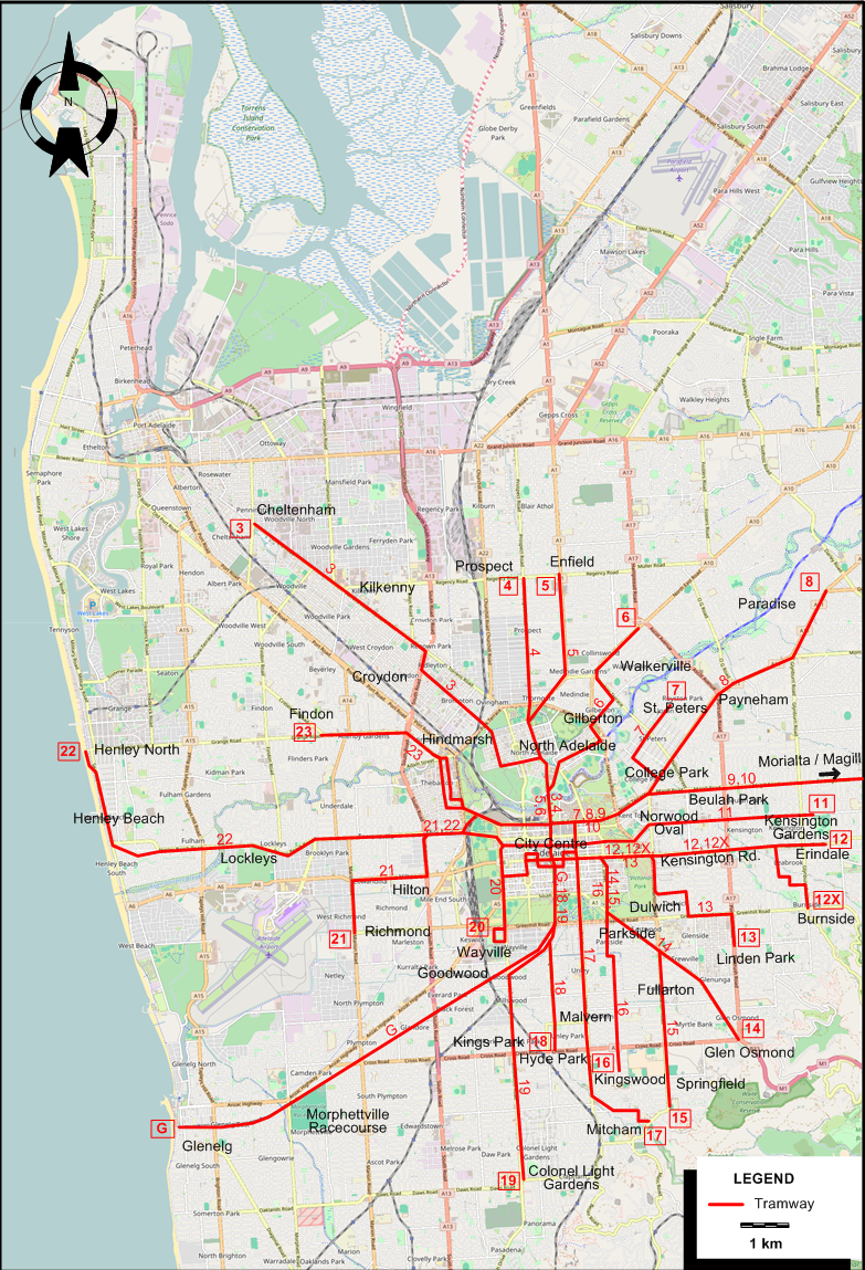
TRAM ROUTES
Operator: Municipal Tramways Trust
| G |
Glenelg |
|
City Centre - Goodwood - Morphettville Racecourse - Glenelg |
| 3 |
Cheltenham |
1958/11/22 |
City Centre - North Adelaide - Croydon - Kilkenny - Cheltenham |
| 4 |
Prospect |
1958/7/20 |
City Centre - North Adelaide - Prospect |
| 5 |
Enfield |
1957/12/8 |
City Centre - North Adelaide - Enfield |
| 6 |
Walkerville North |
1955/11/? |
City Centre - North Adelaide - Gilberton - Walkerville |
| 7 |
St. Peters |
1958/7/? |
City Centre - College Park - St. Peters |
| 8 |
Paradise |
1958/7/? |
City Centre - College Park - Payneham - Paradise |
| 9 |
Morialta |
1956/3/17 |
City Centre - Beulah Park - Morialta |
| 10 |
Magill |
1957/2/? |
City Centre - Beulah Park - Magill |
| 11 |
Kensington Gardens |
1957/2/3 |
City Centre - Norwood Oval - Kensington Gardens |
| 12 |
Erindale |
1952/5/24 |
City Centre - Kensington Rd. - Erindale |
| 12X |
Burnside |
1952/5/24 |
City Centre - Kensington Rd. - Burnside |
| 13 |
Linden park |
1952/5/24 |
City Centre - Dulwich - Linden Park |
| 14 |
Glen Osmond |
1953/10/? |
City Centre - Parkside - Glen Osmond |
| 15 |
Fullarton / Springfield |
1958/7/? |
City Centre - Parkside - Fullarton - Springfield |
| 16 |
Kingswood |
1955/7/? |
City Centre - Parkside - Kingswood |
| 17 |
Mitcham |
1958/7/? |
City Centre - Malvern - Mitcham |
| 18 |
Hyde Park |
1955/11/? |
City Centre - Hyde Park |
| 19 |
Colonel Light Gardens |
1957/12/8 |
City Centre - Goodwood - Kings Park - Colonel Light Gardens |
| 20 |
Wayville West |
1957/12/? |
City Centre - Wayville West |
| 21 |
Hilton / Richmond |
1957/2/? |
City Centre - Hilton - Richmond |
| 22 |
Henley North |
1957/2/3 |
City Centre - Lockleys - Henley Beach - Henley North |
| 23 |
Findon |
1953/10/? |
City Centre - Hindmarsh - Findon |
NB (1): The route numbers given above and on the map are for the convenience of readers, and were not used by the operator (who used the route designation given in the second column). I adopted them from the map designed by
R.T. Horne (see in the printed sources). The dates in the table above are those of the abandonment of the route in question.
NB (2): All routes terminated in the city centre, but I have no sources as to where the city terminal of any one route was. In any case, many routes
were part of through services, with no actual terminal in the city centre, just a change of route designation. For example, the Cheltenham - Wayville West (routes 3 and 20)
were part of a through service.
CHARACTERISTICS OF THE SYSTEM
NETWORK LENGTH
|