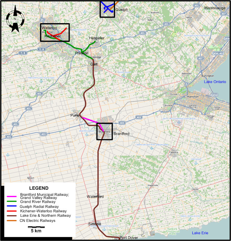
OVERALL SYSTEM MAP
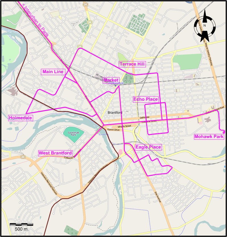
INSET: BRANTFORD
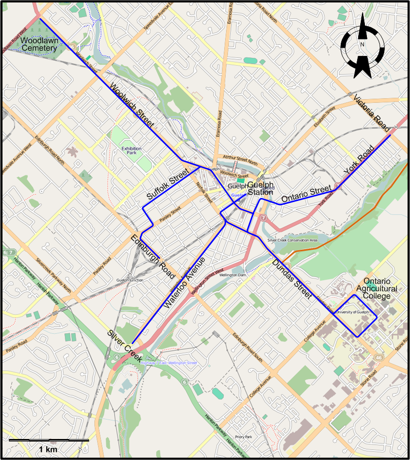
INSET: GUELPH
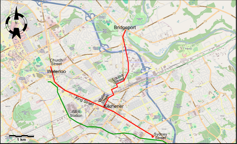
INSET: KITCHENER-WATERLOO
ROUTES
URBAN STREETCAR ROUTES
BRANTFORD
Operator: Brantford Municipal Railway
Note: Streetcar lines in Brantford were identified by the part of the town being served. I have no information as to where their downtown terminuses
were.
Here is a list of the streetcar routes in 1929:
- Eagle Place
- Echo Place
- Holmedale
- Main Line
- Market
- Mohawk Park
- Terrace Hill
- West Brantford
GUELPH
Note: Streetcar lines in Guelph started at the Guelph CNR Station, and were identified by their destination.
Operator: Hydro Electric Railways (formerly, Guelph Radial Railway)
Here is a list of the streetcar routes in 1929:
- Edinburgh Road (through Suffolk Street)
- Ontario Agricultural College (through Dundas Street)
- Victoria Road (through Ontario Street - York Road)
- Waterloo Avenue (to Silver Creek)
- Woodlawn Cemetery (through Woolwich Street)
KITCHENER-WATERLOO
Operator: Kitchener-Waterloo Railways
| King Street Line |
Waterloo (Church Street) - Kitchener (along King Street) - Sydney Street |
| Bridgeport Line |
Downtown Kitchener (King Street) - Water Street - Louisa Street - Bridgeport |
INTERURBAN STREETCAR ROUTES
| Canadian National Electric Railways |
Toronto (St. Clair & Keele) - Churchville - Georgetown - Guelph (CNR Station) |
| Grand River Railway |
Waterloo - Kitchener GRR Station - Preston - Galt |
| Grand River Railway |
Preston - Hespeler |
| Grand Valley Railway |
Brantford - Paris |
| Lake Erie & Northern Railway |
Galt - Paris - Brantford - Waterford - Simcoe - Port Dover |
CHARACTERISTICS OF THE SYSTEM
NETWORK LENGTH
- Brantford Municipal Railway: ? km.
- Canadian National Electric Railways (Toronto- Guelph): 79 km.
- Grand River Railway: 30 km.
- Guelph Hydro Electric Railways: ? km.
- Kitchener-Waterloo Railway: ca. 9 km.
- Lake Erie & Northern Railway: 82 km.
|