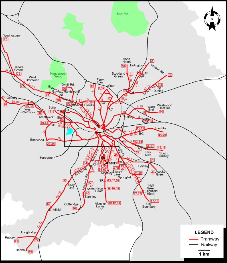
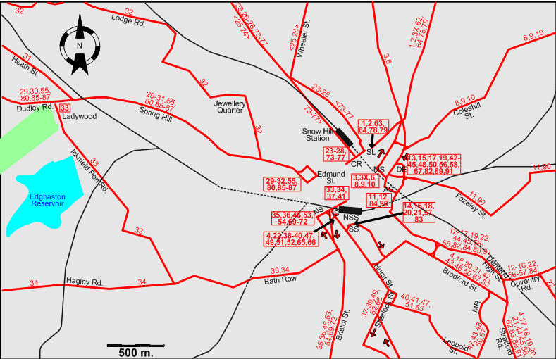
| 1 |
Steelhouse Lane - Aston Cross - Gravelly Hill - Stockland Green |
| 2 |
Steelhouse Lane - Aston Cross - Gravelly Hill - Erdington (Chester Rd.) |
| 3 |
Martineau St. - Aston Six Ways - Witton |
| 3X |
Martineau St. - Aston Cross - Witton |
| 4 |
Hill St. - Bradford St. - Stratford Rd. - Stoney Lane |
| 5 |
Lozells - Aston Six Ways - Gravelly Hill |
| 6 |
Martineau St. - Aston Six Ways - Perry Barr |
| 8 |
Martineau St. - Coleshill St. - Saltley - Alum Rock |
| 9 |
Martineau St. - Coleshill St. - Saltley - Ward End |
| 10 |
Martineau St. - Coleshill St. - Saltley - Ward End - Washwood Heat Rd. |
| 11 |
Albert St. - Fazeley St. - Bordesley Green |
| 12 |
Albert St. - Deritend High St. - Coventry Rd. - Bordesley Green |
| 13 |
Dale End - Deritend High St. - Coventry Rd. - Small Heath |
| 14 |
Station St. - Deritend High St. - Coventry Rd. - Small Heath |
| 15 |
Dale End - Deritend High St. - Coventry Rd. - Small Heath - Hay Mills - South Yardley |
| 16 |
Station St. - Deritend High St. - Coventry Rd. - Small Heath - Hay Mills - South Yardley |
| 17 |
Dale End - Deritend High St. - Stratford Rd. - Springfield - Hall Green - City Boundary |
| 18 |
Station St. - Bradford St. - Stratford Rd. - Springfield - Hall Green - City Boundary |
| 19 |
Dale End - Deritend High St. - Stratford Rd. - Showell Green Lane |
| 20 |
Station St. - Bradford St. - Stratford Rd. - Showell Green Lane |
| 21 |
Station St. - Bradford St. - Stratford Rd. - Springfield (College Rd.) |
| 22 |
Hill St. - Deritend High St. - Coventry Rd. - Bolton Rd. |
| 23 |
Colmore Row - Hockley - Soho Rd. - Handsworth (Birmingham Rd.) |
| 24 |
Colmore Row - Wheeler St. - Lozells - Colmore Row [Loop, Counterclockwise] |
| 25 |
Colmore Row - Lozells - Wheeler St. - Colmore Row [Loop, Clockwise] |
| 26 |
Colmore Row - Hockley - Oxhill Rd. |
| 27 |
Colmore Row - Hockley - Handsworth (Soho Rd.) |
| 28 |
Colmore Row - Hockley - Soho Rd. - Handsworth (New Inns) |
| 29 |
Edmund St. - Spring Hill - Dudley Rd. - Cape Hill - Bearwood |
| 30 |
Edmund St. - Spring Hill - Dudley Rd. - Cape Hill |
| 31 |
Edmund St. - Spring Hill - Heath St. - Soho |
| 32 |
Edmund St. - Jewellery Quarter - Lodge Rd. - Foundry Rd. |
| 33 |
Navigation St. - Bath Row - Icknield Port Rd. - Ladywood |
| 34 |
Navigation St. - Bath Row - Hagley Rd. - Bearwood |
| 35 |
Navigation St. - Bristol St. - Bristol Rd. - Selly Oak |
| 36 |
Navigation St. - Bristol St. - Bristol Rd. - Pershore Rd. - Cotteridge |
| 37 |
Navigation St. - Hurst St. - Sherlock St. - Cannon Hill Park |
| 38 |
Hill St. - Hurst St. - Sherlock St. - Park Rd. - Moseley - Kings Heath |
| 39 |
Hill St. - Hurst St. - Sherlock St. - Park Rd. - Moseley - Kings Heath - Alcester Lanes End |
| 40 |
Hill St. - Hurst St. - Leopold St.. - Mosely Rd. - Moseley - Kings Heath |
| 41 |
Navigation St. - Hurst St. - Leopold St.. - Mosely Rd. - Moseley Rd. Depot |
| 42 |
Dale End - Bradford St. - Moseley Rd. - Moseley - Kings Heath - Alcester Lanes End |
| 43 |
Dale End - Bradford St. - Moseley Rd. - Moseley - Station Rd. |
| 44 |
Dale End - Deritend High St. - Stratford Rd. - Warwick Rd. - Tyseley - Acocks Green |
| 45 |
Dale End - Deritend High St. - Stratford Rd. - Sparkbrook |
| 46 |
Navigation St. - Bristol St. - Bristol Rd. - Pershore Rd. - Stirchley |
| 47 |
Hill St. - Hurst St. - Leopold St.. - Mosely Rd. - Moseley - Station Rd. |
| 48 |
Dale End - Bradford St. - Moseley Rd. - Moseley - Kings Heath |
| 49 |
Hill St. - Hurst St. - Sherlock St. - Park Rd. |
| 50 |
Dale End - Bradford St. - Moseley Rd. - - Moseley Rd. Depot |
| 51 |
Hill St. - Hurst St. - Leopold St.. - Mosely Rd. - Moseley - Kings Heath - Alcester Lanes End |
| 52 |
Hill St. - Hurst St. - Sherlock St. - Park Rd. - Moseley - Station Rd. |
| 53 |
Navigation St. - Bristol St. - Bristol Rd. - Pershore Rd. - Ten Acres |
| 54 |
Navigation St. - Bristol St. - Bristol Rd. - Pebble Mill Rd. |
| 55 |
Edmund St. - Spring Hill - Dudley Rd./Grove Lane |
| 56 |
Dale End - Deritend High St. - Coventry Rd. - Small Heath - Hay Mills |
| 57 |
Station St. - Deritend High St. - Coventry Rd. - Small Heath - Hay Mills |
| 58 |
Dale End - Deritend High St. - Bradford St. - Stratford Rd. - Stoney Lane |
| 63 |
Steelhouse Lane - Aston Cross - Gravelly Hill - Tyburn Rd. - Fort Dunlop |
| 64 |
Steelhouse Lane - Aston Cross - Gravelly Hill - Erdington (High St.) |
| 65 |
Hill St. - Hurst St. - Leopold St.. - Mosely Rd. - Moseley |
| 66 |
Hill St. - Hurst St. - Sherlock St. - Park Rd. - Moseley |
| 67 |
Dale End - Bradford St. - Moseley Rd. - Moseley |
| 69 |
Navigation St. - Bristol St. - Bristol Rd. - North Field |
| 70 |
Navigation St. - Bristol St. - Bristol Rd. - North Field - Longbridge - Rednal |
| 71 |
Navigation St. - Bristol St. - Bristol Rd. - North Field - Longbridge - Rubery |
| 72 |
Navigation St. - Bristol St. - Bristol Rd. - North Field - Longbridge |
| 73 |
Colmore Row - Hockley - Soho Rd. - Handsworth - West Bromwich - Carters Green |
| 74 |
Colmore Row - Hockley - Soho Rd. - Handsworth - West Bromwich - Carters Green - Great Bridge - Dudley |
| 75 |
Colmore Row - Hockley - Soho Rd. - Handsworth - West Bromwich - Carters Green - Wednesbury |
| 76 |
Colmore Row - Hockley - Soho Rd. - Handsworth - West Bromwich - Carters Green - Great Bridge |
| 77 |
Colmore Row - Hockley - Soho Rd. - Handsworth - West Bromwich |
| 78 |
Steelhouse Lane - Aston Cross - Gravelly Hill - Stockland Green - Short Heath |
| 79 |
Steelhouse Lane - Aston Cross - Gravelly Hill - Tyburn Rd. - Chester Rd. |
| 80 |
Edmund St. - Spring Hill - Dudley Rd. - Cape Hill - Smethwick |
| 82 |
Dale End - Deritend High St. - Stratford Rd. - Springfield - Hall Green (Highfield Rd.) |
| 83 |
Station St. - Bradford St. - Stratford Rd. - Springfield - Hall Green (Highfield Rd.) |
| 84 |
Albert St. - Deritend High St. - Coventry Rd. - Bordesley Green - Stechford |
| 85 |
Edmund St. - Spring Hill - Dudley Rd. - Cape Hill - Smethwick - West Smethwick |
| 86 |
Edmund St. - Spring Hill - Dudley Rd. - Cape Hill - Smethwick - West Smethwick - Oldbury |
| 87 |
Edmund St. - Spring Hill - Dudley Rd. - Cape Hill - Smethwick - West Smethwick - Oldbury - Dudley |
| 88 |
Cape Hill - Smethwick - West Smethwick |
| 89 |
Dale End - Deritend High St. - Stratford Rd. - Springfield (College Rd.) |
| 90 |
Albert St. - Fazeley St. - Bordesley Green - Stechford |
| 91 |
Dale End - Deritend High St. - Stratford Rd. - Warwick Rd. - Tyseley |