|
|
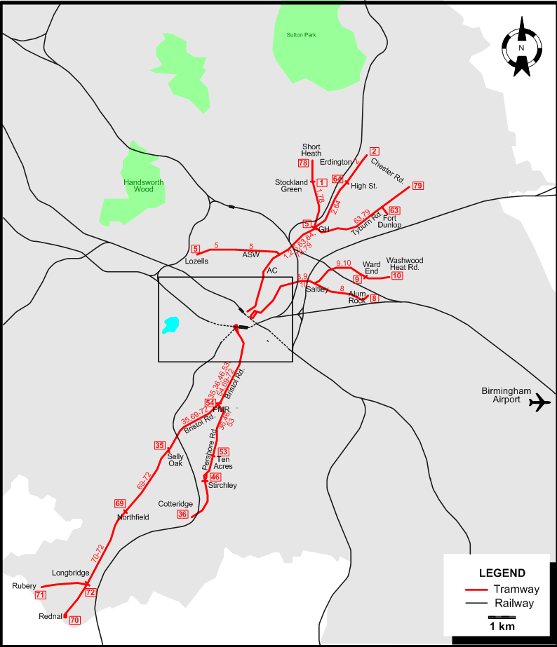
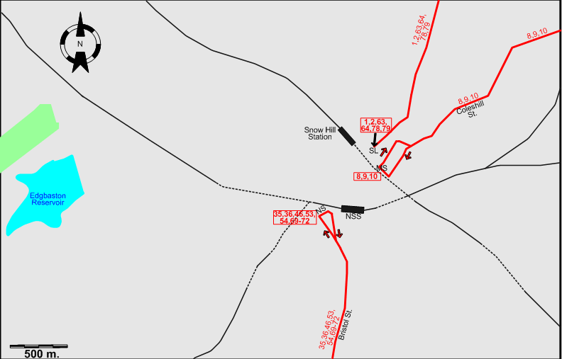
INSET: DOWNTOWN BIRMINGHAM
ABBREVIATIONS ON THE MAPS
| AC |
Aston Cross |
NS |
Navigation St. |
| ASW |
Aston Six Ways |
NSS |
New Street Station |
| GH |
Gravelly Hill |
PMR |
Pebble Mill Rd. |
| MS |
Martineau St. |
SL |
Steelhouse Lane |
Chronology of major track abandonments 1940-1949 (with affected routes in parentheses)
- Edmund St. - Foundry Rd. (32): 29 March 1947
- Ladywood route (33): 30 Aug. 1947
- Stechford / South Yardley group of routes (11, 12, 13, 15, 56, 84, 90): 2 Oct. 1948
- Cannon Hill Park route (37): 1 Oct. 1949
- Moseley / Cannon Hill Park group of routes (37, 38, 39, 40, 41, 42, 48, 49, 50, 51, 65, 66, 67): 1 Oct. 1949
- Martineau St. - Aston Six Ways - Perry Barr (6): 21 Dec. 1949
- Aston Cross- Witton (3X): 31 Dec. 1949
Chronology of major track abandonments 1950-1953 (closure of the system) (with affected routes in parentheses)
- Lozells route (5): 30 Sept. 1950
- Saltley routes (8, 9, 10): 30 Sept. 1950
- Pershore Rd. routes (36, 46, 53): 5 May 1952
- Bristol Rd. routes (35, 54, 69, 70, 71, 72): 5 July 1952
- Erdington routes (2, 64): 4 June 1953
- Stockland Green / Tyburn group of routes (1, 63, 78, 79): 4 July 1953
Operator: Birmingham Corporation Tramways
| 1 |
Steelhouse Lane - Aston Cross - Gravelly Hill - Stockland Green |
| 2 |
Steelhouse Lane - Aston Cross - Gravelly Hill - Erdington (Chester Rd.) |
| 5 |
Lozells - Aston Six Ways - Gravelly Hill |
| 8 |
Martineau St. - Coleshill St. - Saltley - Alum Rock |
| 9 |
Martineau St. - Coleshill St. - Saltley - Ward End |
| 10 |
Martineau St. - Coleshill St. - Saltley - Ward End - Washwood Heat Rd. |
| 35 |
Navigation St. - Bristol St. - Bristol Rd. - Selly Oak |
| 36 |
Navigation St. - Bristol St. - Bristol Rd. - Pershore Rd. - Cotteridge |
| 46 |
Navigation St. - Bristol St. - Bristol Rd. - Pershore Rd. - Stirchley |
| 53 |
Navigation St. - Bristol St. - Bristol Rd. - Pershore Rd. - Ten Acres |
| 54 |
Navigation St. - Bristol St. - Bristol Rd. - Pebble Mill Rd. |
| 63 |
Steelhouse Lane - Aston Cross - Gravelly Hill - Tyburn Rd. - Fort Dunlop |
| 64 |
Steelhouse Lane - Aston Cross - Gravelly Hill - Erdington (High St.) |
| 69 |
Navigation St. - Bristol St. - Bristol Rd. - North Field |
| 70 |
Navigation St. - Bristol St. - Bristol Rd. - North Field - Longbridge - Rednal |
| 71 |
Navigation St. - Bristol St. - Bristol Rd. - North Field - Longbridge - Rubery |
| 72 |
Navigation St. - Bristol St. - Bristol Rd. - North Field - Longbridge |
| 78 |
Steelhouse Lane - Aston Cross - Gravelly Hill - Stockland Green - Short Heath |
| 79 |
Steelhouse Lane - Aston Cross - Gravelly Hill - Tyburn Rd. - Chester Rd. |
NETWORK LENGTH
|