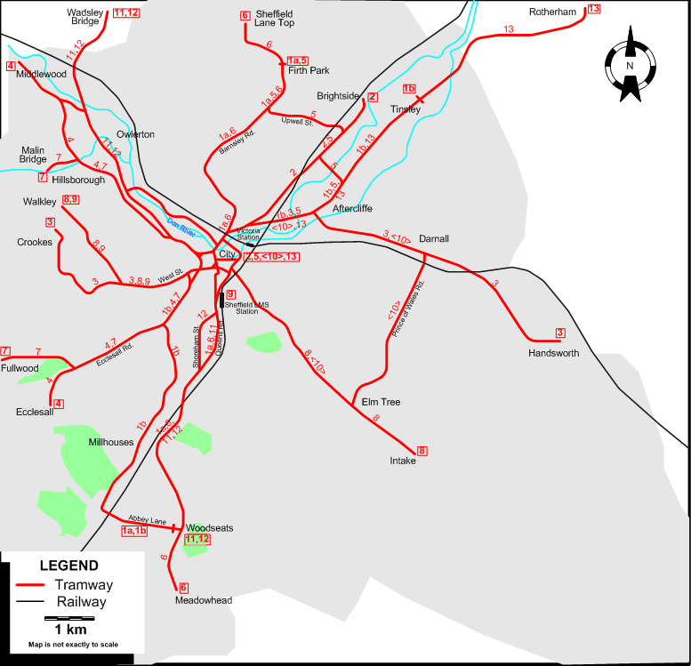
Operator: Sheffield Corporation Tramways
ROUTES
Route numbers are indicative only, and were not used.
| 1a |
Firth Park - Barnsley Rd. - City - Station - Queens Rd. - Woodseats - Abbey Lane (continues as 1b) |
| 1b |
Tinsley - Aftercliffe - City - Millhouses - Abbey Lane (continues as 1a) |
| 2 |
City - Brightside |
| 3 |
Crookes - West St. - City - Darnall - Handsworth |
| 4 |
Middlewood - Hillsborough - City - Ecclesall Rd. - Ecclesall |
| 5 |
City - Aftercliffe - Upwell St. - Firth Park |
| 6 |
Sheffield Lane Top - Firth Park - Barnsley Rd. - City - Station - Queens Rd. - Woodseats - Meadowhead |
| 7 |
Malin Bridge - Hillsborough - City - Ecclesall Rd. - Fulwood |
| 8 |
Walkley - West St. - City - Elm Tree - Intake |
| 9 |
Walkley - West St. - City - Station |
| 10 |
City - Elm Tree - Prince of Wales Rd. - Darnall - City [Circular route, both directions] |
| 11 |
Wadsley Bridge - City - Queens Rd. - Woodseats |
| 12 |
Wadsley Bridge - City - Shoreham St. - Woodseats |
| 13 |
Rotherham - Tinsley - Aftercliffe - City [Operated jointly with Rotherham Corporation] |
NETWORK LENGTH
|