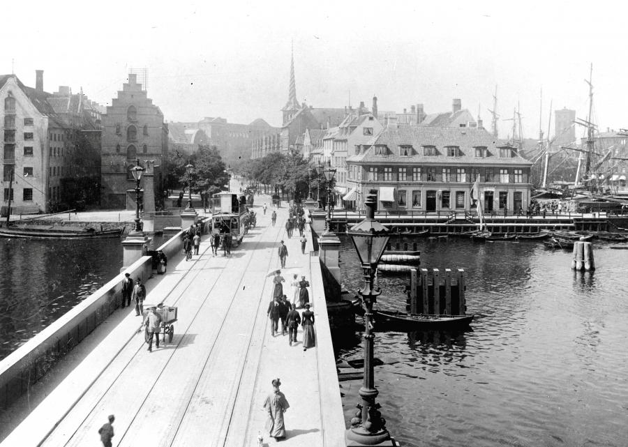
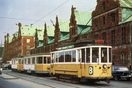
PHOTOS
| 
|
MAPS
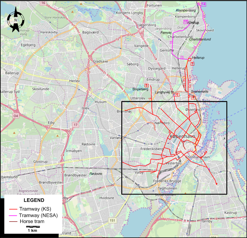
INSET: CENTRAL COPENHAGEN

ABBREVIATIONS ON THE MAPS
| HCA | H.C. Andersens Boulevard | Vb | Vesterbrogade |
| NEV | Niels Ebbesens Vej | VV | Vester Voldgade |
| Rp | Raadhusplads |
I created the above maps by overlaying OpenStreetMap (OSM) maps with my own data. The underlying map data is © OpenStreetMap contributors, licensed under the Open Database License (ODbL).
Please note that the OSM maps used as a template for these maps corresponds to the situation at the time the map was downloaded and may show features that did not exist at the time the GS Tram Site is supposed to show. In particular, it may show bridges and highways that were built later.
ROUTES
ELECTRIC TRAM ROUTES
Operator: De kjøbenhavnske Sporveje (DKS).
| 1 | Frederiksberg RDDL - Frederiksberg Allé – Vesterbrogade - Raadhusplads – Vester Voldgade - Højbro – Kongens Nytorv – Bredgade [back: St. Kongensgade] – Østerport – Trianglen – Østerbrogade – Svanemølle – Hellerup |
| 2 | Valby – Valby Langgade – Pile Allé - Vesterbrogade – Raadhusplads – Højbro – Christiansborg - Christianshavn – Amagerbrogade – Sundby |
| 3 | Enghave Remise – Enghavevej – Enghave Plads - H. C. Ørsteds Vej – Blegdamsvej – Trianglen – Strandboulevard |
| 4 | Svanemølle – Østerbrogade – Trianglen – Øster Farimagsgade – Raadhusplads |
| 5 | Brønshøj / Bispebjerg – Nørrebro station – Nørrebrogade – Frederiksborggade – Nørreport – Øster Farimagsgade - Vesterbrogade – Raadhusplads – Langebro – Amager Boulevard – Holmbladsgade |
| 6 | Toftegaards Plads / Vestre Kirkegaard - Istedgade - Hovedbanegaarde - Højbro – Kongens Nytorv – Bredgade [back: St. Kongensgade] – Østerport – Trianglen – Øster Allé – Lyngbyvej – Lyngbyvej St. |
| 7 | Skodsborggade – Nørrebrogade – Frederiksborggade – Nørreport – Gothersgade – Kongens Nytorv |
| 8 | Raadhusplads - Vesterbrogade - Vodroffsvej - Niels Ebbesens Vej - H. C. Ørsteds Vej - Kapelvej |
| 9 | [Sundby – Amagerbrogade] / [Christianshavn - Princessegade] – Christiansborg – Kongens Nytorv – Bredgade [back: St. Kongensgade] – Østerport – Strandboulevard – Østerbrogade |
| 10 | Kongens Nytorv – Sølvgade – Tagensvej – Bispebjerg |
Note: Lines 14 and 15 were operated jointly with NESA. See below for routing.
HORSE TRAM ROUTE
Operator: De kjøbenhavnske Sporveje (DKS).
| 11 | Vendersgade - Gammeltorv |
SUBURBAN ELECTRIC TRAM ROUTES
Operator: Nordsjællands Elektricitets- og Sporvejs Aktieselskab (NESA)
| 14 | Klampenborg - Charlottenlund - Hellerup – Svanemøllen – Østerbrogade – Trianglen – Øster Farimagsgade – Nørreport – Raadhusplads |
| 15 | Ordrup - Femvej - Gentofte - Hellerup – Svanemøllen – Østerbrogade – Trianglen – Øster Farimagsgade – Nørreport – Raadhusplads |
Note: The two NESA tram lines ran on KS tracks in the central Copenhagen area.
CHARACTERISTICS OF THE SYSTEM
NETWORK LENGTH
- Electric trams: ? km.
- Horse trams: ca. 1 km
HISTORY
- Urban tramways: (horse-drawn) 22 Oct. 1863 - 14 June 1915; (electric): 1 Aug. 1901 - 23 Apr. 1972.
- Metro: 19 Oct. 2002 - today.
- S-tog (S-train): 3 Apr. 1934 - today.
GAUGE
- Urban tramways: 1435 mm.
- Metro: 1435 mm.
- S-tog (S-train): 1435 mm.
TRAM PRESERVATION
The Sporvejsmuseet Skjoldenæsholm (Skjoldenæsholm Tram Museum), 65 km SW of Copenhagen, runs old trams (from Copenhagen, Odense, Aarhus and from outside Denmark) on 1.8 km of track (1.5 km standard gauge; 300 m metre gauge).
SOURCES
- "Breaking new ground in Denmark",Tramways & Urban Transit, Apr. 2026 (89: 1060), p.142-143.
WIKIS
- Copenhagen Metro
- Hovedstadens Udviklingsråd (HUR)
- Kjøbenhavns Forstæders Sporveisselskab
- Københavns Sporveje [Copenhagen Tramways]
- NESA
- S-tog / S-train
WEB SITES
- Copenhagen (on UrbanRail.Net)
- Moviatrafik
- S-tog
- Sporvogne & sporveje / Trams and tramways
- Sporvogne i Danmark
- Trams in Copenhagen
My profound thanks to Nils Lindgren of Sweden and the Danish tramway historical society BYtrafik for sending me information useful for the preparation of this page.
Copyright Gabor Sandi 1998-2026
Disclaimer: Everything on this site was written and/or prepared at the author's discretion. The author has tried to be accurate where facts are presented, but this does not mean that these facts are necessarily accurate. People needing more reliable information should refer to appropriate sources presented, on the Internet or elsewhere, by authoritative professional or academic bodies.
To get in touch with the webmaster, send an e-mail to g_sandi at hotmail.com.
Flags on this site are from the FOTW Flags Of The World website.