VIDEO
 |
| Above: YouTubeCA video - Calgary Remembered On KSPS, Mar 12 1998 (Part 3 of 13) - Length: 4:26 mins. |
PHOTO
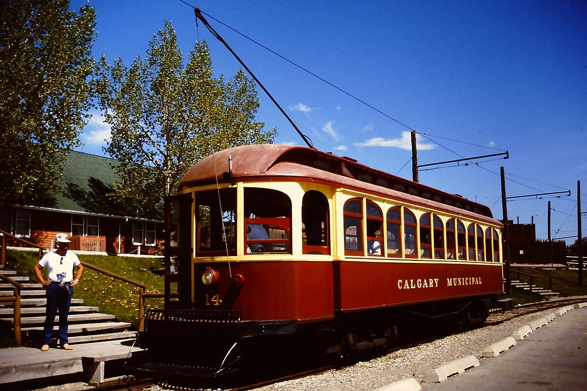 |
MAP
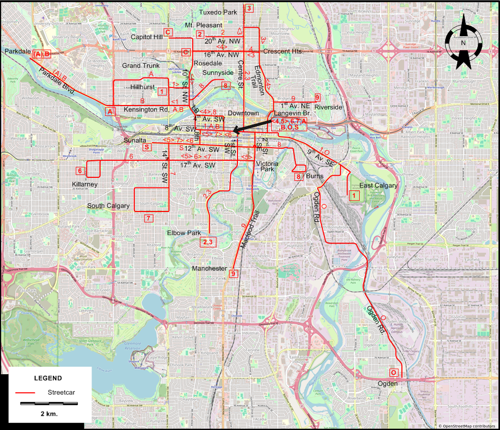
ABBREVIATION ON THE MAP
| LB | Louise Bridge |
I created the above map by overlaying OpenStreetMap (OSM) maps with my own data. The underlying map data is © OpenStreetMap contributors, licensed under the Open Database License (ODbL).
Please note that the OSM map used as a template for this map corresponds to the situation at the time the map was downloaded and may show features that did not exist at the time the GS Tram Site is supposed to show. In particular, it may show bridges and highways that were built later.
ROUTES
URBAN STREETCAR ROUTES
Operator: Calgary Municipal Railway
| 1 | Hillhurst - Louise Bridge - Downtown – 9th Av. SE - East Calgary |
| 2 | Mount Pleasant – 20th Av. NW - Centre St. - Downtown – Elbow Park |
| 3 | Tuxedo Park – Crescent Heights - Centre St. - Downtown – Elbow Park |
| 4 | Downtown – Langevin Br. (now Reconciliation Br.) - Edmonton Trail - Crescent Heights - 16th Av. NW - Rosedale - 10th St. NW - Hillhurst - Louise Bridge - 4th Av. SW - Downtown [Circular route, both directions] |
| 5 | Downtown – 8th Av. S - 8th St. SW - 12th Av. SW - 14th St. SW - 17th Av. SW - Victoria Park - 2nd St. SE - Downtown [Circular route, both directions] |
| 6 | Downtown – [8th Av. S - 8th St. SW - 12th Av. SW - 14th St. SW] [back: 17th Av. SW - 1st St. SW] - 17th St. SW - Killarney |
| 7 | Downtown – [1st St. SW - 17h Av. SW] [back: 14th St. SW - 12th Av. SW - 8th St. SW - 8th Av. S] - 14th St. SW - South Calgary |
| 8 | Sunnyside - Louise Bridge - Downtown – Burns |
| 9 | Riverside - 1st Av. NE - Langevin Br. (now Reconciliation Br.) - Downtown – 2nd St. SE -Victoria Park - Macleod Trail - Manchester |
| A | Downtown – 8th Av. SW - Louise Bridge - Hillhurst - Grand Trunk - Kensington Rd. [ - Parkdale Blvd. - Parkdale (morning rush-hours)] |
| B | Downtown – 8th Av. SW - Louise Bridge - Hillhurst - Kensington Rd. - Parkdale Blvd. - Parkdale |
| C | Rosedale - 20th Av. NW - Capitol Hill |
| O | Downtown – 9th Av. SE - Ogden Rd. - Ogden |
| S | Downtown – 1st St. SW - 12th Av. SW - Sunalta |
CHARACTERISTICS OF THE SYSTEM
NETWORK LENGTH
- Streetcar lines: ? km.
HISTORY
- Streetcars (Old system): 5 July 1909 - 29 Dec. 1950.
- C-Train (LRT): 25 May 1981 - today.
GAUGE
- 1435 mm.
SOURCES
- Hatcher, C.K. Stampede City Streetcars: The Story of the Calgary Municipal Railway. Montreal: Railfare, 1975.
- Jones, A.E. "Second time around! - Part 4: Widening horizons in Calgary" Modern Tramway & Light Rail Transit, Jan. 1982 (45:529), p.20-29.
- Simons, V. "Calgary: Success breeds ambition" Tramways & Urban Transit, Jan. 2015 (78:925), p.9-14.
- Streeter, T. "Double, double, double? - Expanding Calgary's light rail" Tramways & Urban Transit, Aug. 2011 (74:884), p.298-304.
WIKIS
WEB SITES
- Calgary Municipal Railway
- Calgary Transit
- Canadian Street Railways
- Designing Calgary's historic streetcar map, by Saadiq Mohiuddin
Copyright Gabor Sandi 1998-2026
Disclaimer: Everything on this site was written and/or prepared at the author's discretion. The author has tried to be accurate where facts are presented, but this does not mean that these facts are necessarily accurate. People needing more reliable information should refer to appropriate sources presented, on the Internet or elsewhere, by authoritative professional or academic bodies.
To get in touch with the webmaster, send an e-mail to g_sandi at hotmail.com.
Flags on this site are from the FOTW Flags Of The World website.