VIDEOS
 |
 |
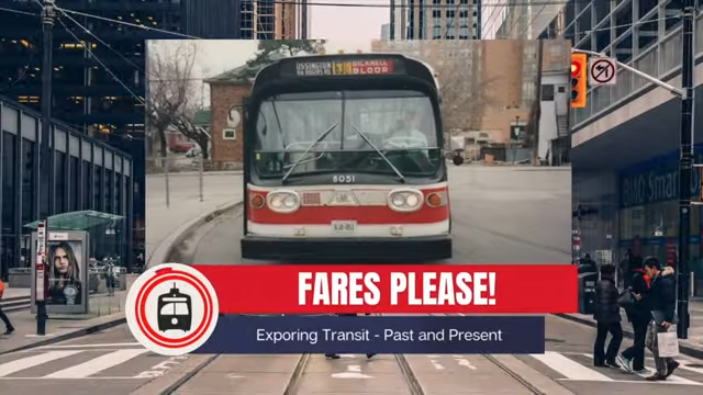
| Above: YouTubeCA video - Toronto Streetcar Documentary 1988 : The PCC Era , Toronto's Red Rockets TTC - Length: 58:50 mins. | Above: YouTubeCA video - Original Toronto Subway Cars in the 1980s - Length: 43:39 mins. |
PHOTOS
 |
 |
MAPS
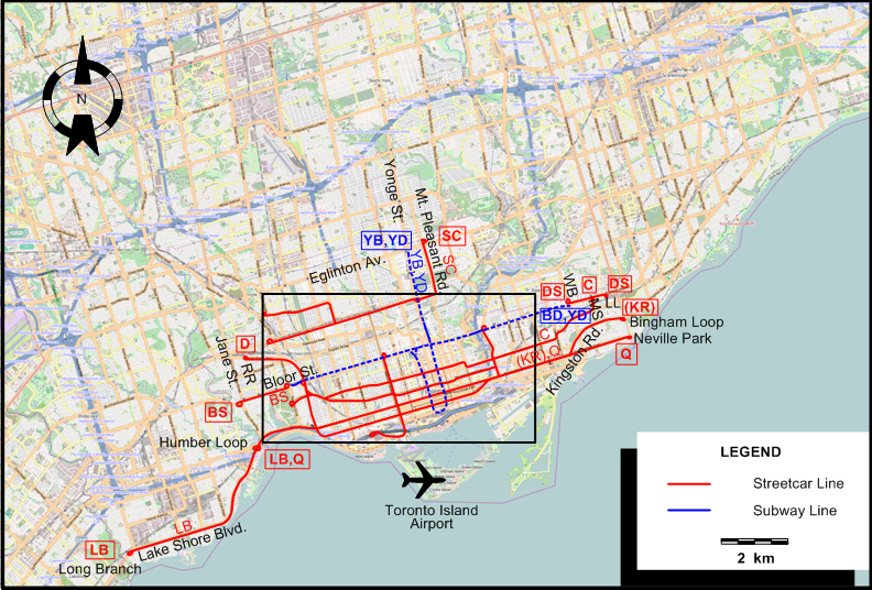
INSET: CENTRAL TORONTO
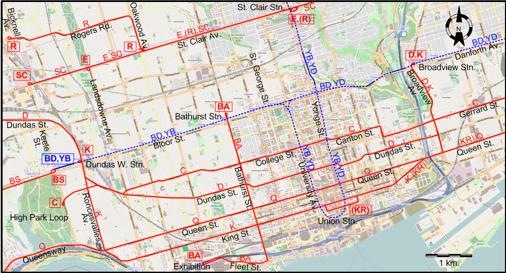
ABBREVIATIONs ON THE MAPS
| LL | Luttrell Loop | RR | Runnymede Rd. |
| MS | Main Street | WB | Woodbine Av. |
I created the above maps by overlaying OpenStreetMap (OSM) maps with my own data. Copyright on the OSM maps is © OpenStreetMap contributors, licensed under a CC-BY-SA (Creative Commons Attribution-ShareAlike 2.0 licence).
Please note that the OSM maps used as templates for these maps correspond to the situation at the time the maps were downloaded and may show features that did not exist at the time the GS Tram Site is supposed to show. In particular, they may show bridges and highways that were built later.
Discontinuation of routes on 11 May 1968 (after the extensions of the Bloor subway to Islington and Warden):
- Bloor Shuttle (BS)
- Danforth Shuttle (DS)
- Dundas streetcar route (D) north of Dundas West station
ROUTES
Operator: Toronto Transit Commission (TTC)
Note: The lettered route designations are of an indicative nature only, they were never used as such. The official names of the routes are given in the second column in capitals.
STREETCAR ROUTES
| BA | BATHURST | Exhibition - Fleet St. - Bathurst St. - Bathurst & Bloor |
| BS | BLOOR SHUTTLE | Jane & Bloor - Bloor St. - Keel Station |
| C | CARLTON | High Park Loop - College St. - Carlton St. - Gerrard St. - Main St. - Main & Danforth |
| D | DUNDAS | Runnymede & Dundas - Dundas St. - Gerrard St. - Broadview Ave. - Broadview & Danforth |
| DS | DANFORTH SHUTTLE | Danforth & Woodbine - Danforth Ave. - Luttrell Loop |
| E | EARLSCOURT | Lansdowne & St. Clair - St Clair Ave. - Yonge & St. Clair |
| K | KING | Dundas W & Bloor - Roncesvalles Ave. - King St. - Queen St. - Broadview Ave. - Broadview & Danforth |
| KR | KINGSTON ROAD | [Church St. - Wellington St. - York St. Loop] - King St. - Queen St. - Kingston Rd. - Victoria Park Ave. & Kingston Rd. (Bingham Loop) [Rush hours and midday only] |
| LB | LONG BRANCH | Humber Loop - Lake Shore Blvd. - Long Branch |
| Q | QUEEN | Humber Loop - Queensway - Queen St. - Neville Park |
| R | ROGERS ROAD | Bicknell & Rogers Road - Rogers Road - Oakwood Ave. - Oakwood & St. Clair [In rush hours: - St. Clair Ave. - Yonge & St. Clair] |
| SC | ST. CLAIR | Keele & St. Clair - St. Clair Ave. - Mt. Pleasant Rd. - Mt. Pleasant & Eglinton |
SUBWAY ROUTES
| BD | BLOOR-DANFORTH | Bloor & Keele - Bloor - Danforth - Danforth & Woodbine |
| YB | YONGE-BLOOR | Eglinton - Yonge - Union Station - University - Bloor & St.George - Bloor - Bloor & Keele |
| YD | YONGE-DANFORTH | Eglinton - Yonge - Union Station - University - Bay Stn. - Bloor - Danforth - Danforth & Woodbinee |
The three routes represent the interlining of the two subway lines, which ended on 4 Sept. 1966. After that date, the Bloor-Danforth (B) and Yonge-University (Y) lines were run separately.
CHARACTERISTICS OF THE SYSTEM
NETWORK LENGTH
- Streetcars: ? km.
- Subway: ? km.
HISTORY
- Urban treetcars: (horse-powered) 11 Sept. 1861 - 30 Aug. 1894; (electric) 15 Aug. 1892 - today.
- Interurban streetcars: (horse-powered) 26 Jan. 1885 - 1890; (electric, on Yonge North) 1 Sept. 1890 - 10 Oct. 1948; (electric, to the Humber River, then to Mimico & Port Credit) 16 July 1892 - 27 Sept. 1928.
- LRT (Scarborough Rapid Transit): 22 Mar. 1985 - 24 July 2023.
- LRT (Finch West): 7 Dec. 2025 - today.; (Eglinton): 8 Feb. 2026 - today.
- Subway: 30 Mar. 1954 - today.
GAUGE
- Urban streetcars (Toronto): 1495 mm.
- Light rail: 1435 mm.
- Interurban streetcars: 1435 mm. (1885 - 1927); 1495 mm. (1927 - 1948).
- Toronto Suburban Railway (TSR): 1435 mm.
- LRT (Scarborough Rapid Transit; Finch West): 1435 mm.
- Subway: 1495 mm.
SOURCES
- Bromley, J.F. TTC '28: The electric railway services of the Toronto Transportation Commission in 1928. Toronto: Upper Canada Railway Society, 1968.
- Filey, M. Not a one-horse town: 125 years of Toronto and its streetcars. Toronto: [Author], 1986.
- Filey, M. The TTC story: The first seventy-five years. Toronto/Oxford: Dundurn Press, 1996.
- Simons, V. "Toronto: Making the move", Tramways & Urban Transit, Oct. 2013 (76:910), p.420-426.
- Skelsey, G. "Toronto: The TTC's streetcars at 80 (Part 4)", Tramways & Urban Transit, Jan. 2001 (64:757), p.15-18.
- Taplin, M.R. Tramways of North America, including rapid transit.Hassocks (England): Light Rail Transit Association, 1982 (?).
- Wickson, E.A. "Toronto's new Light Rail Line". In: Light Rail Review 2. London: Light Rail Transit Association, 2000 [p.63-65].
WIKIS
- Line 3 Scarborough
- Line 5 Eglinton
- Line 6 Finch West
- Metrolinx
- Metropolitan line (Toronto)
- North Yonge Railways
- Toronto and York Radial Railway
- Toronto streetcar system
- Toronto Suburban Railway
- Toronto subway
- Toronto Transit Commission
WEB SITES
- Canadian Street Railways
- Metrolinx
- Steve Munro's Web Site (dedicated to public transit in Toronto)
- Toronto (on UrbanRailNet)
- Toronto Transit Commission (TTC)
- Transit Toronto
- TTS (Toronto Transportation Society) Online
Copyright Gabor Sandi 1998-2026
Disclaimer: Everything on this site was written and/or prepared at the author's discretion. The author has tried to be accurate where facts are presented, but this does not mean that these facts are necessarily accurate. People needing more reliable information should refer to appropriate sources presented, on the Internet or elsewhere, by authoritative professional or academic bodies.
To get in touch with the webmaster, send an e-mail to g_sandi at hotmail.com.
Flags on this site are from the FOTW Flags Of The World website.