VIDEOS
 |
 |
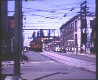 |
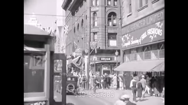
| Above: YouTubeCA video – Downtown Vancouver Streetcar Ride, 1936 – Length: 2:05 mins. | Above: YouTubeCA video – Streetcars and Vancouver: Development History Part I 1886 - 1928 – Length: 12:30 mins. | Above: YouTubeCA video – BCER Interurban - Downtown Vancouver to Marpole – Length: 10:53 mins. |
PHOTOS
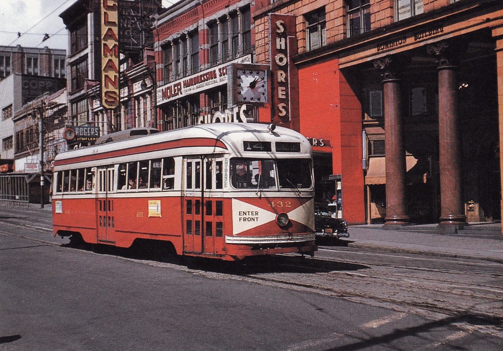 |
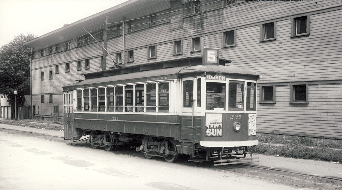 |
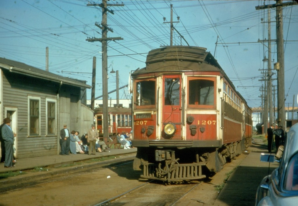 |
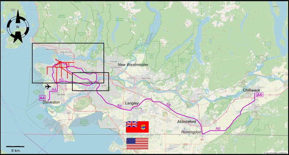
MAPS
VANCOUVER AND THE LOWER FRASER VALLEY
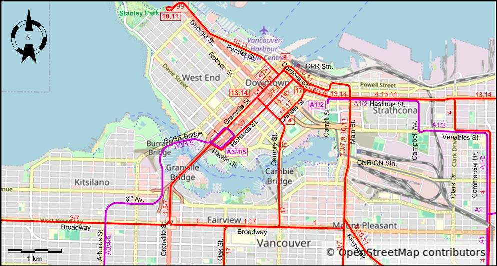
VANCOUVER - MAIN MAP
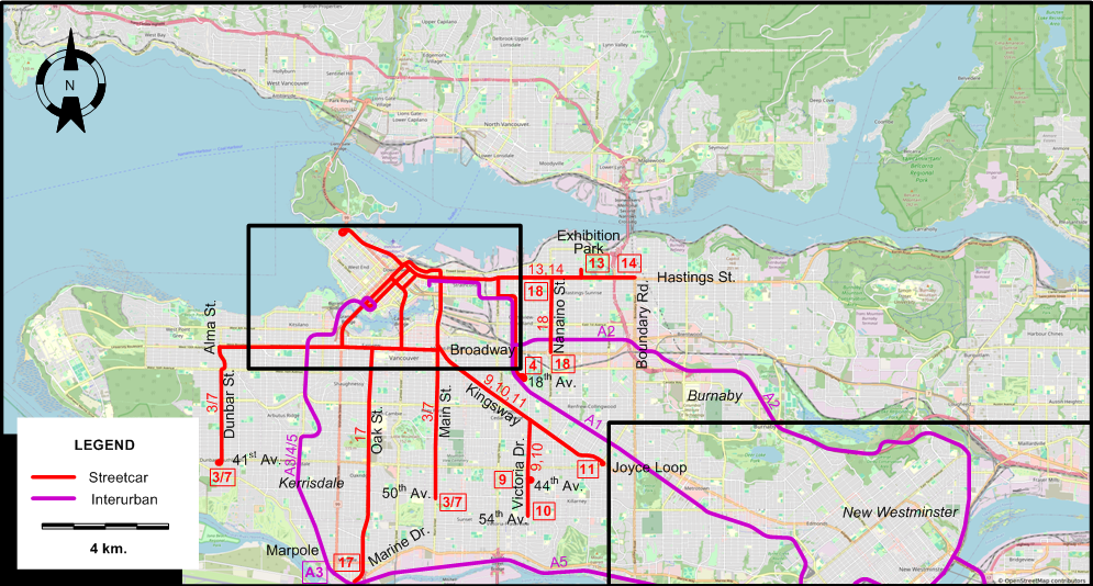
INSET: CENTRAL VANCOUVER
INSET: NEW WESTMINSTER & VICINITY
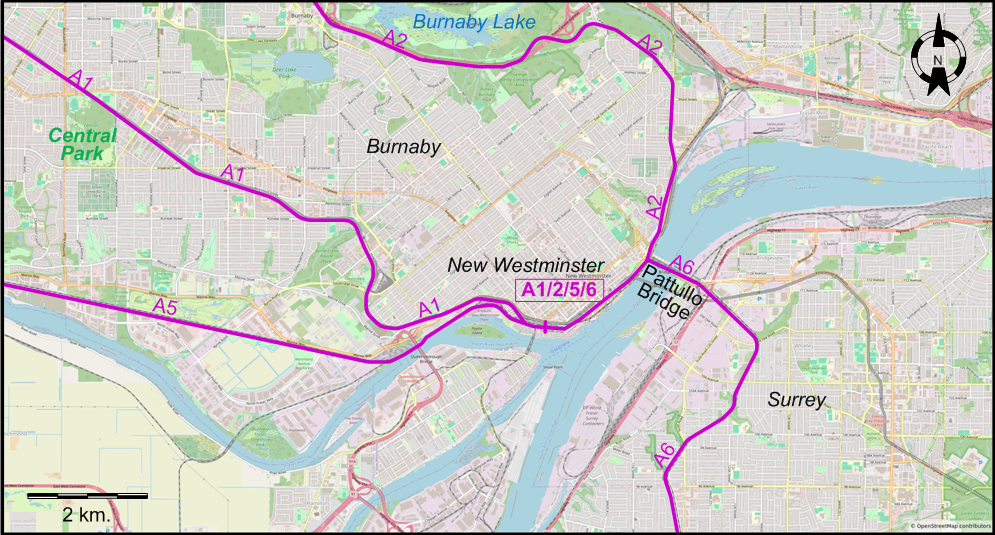
I created the above maps by overlaying OpenStreetMap (OSM) maps with my own data. The underlying map data is © OpenStreetMap contributors, licensed under the Open Database License (ODbL).
Please note that the OSM maps used as a template for these maps corresponds to the situation at the time the map was downloaded and may show features that did not exist at the time the GS Tram Site is supposed to show. In particular, it may show bridges and highways that were built later.
ROUTES
Operator: British Columbia Electric Railway Company (BCER)
URBAN STREETCAR ROUTES (VANCOUVER)
| 1 | Granville St. - Broadway - Main St. - Hastings St. - Granville St. (circular route; both directions) |
| 3/7 | 50th & Main - Main St. - HastingsSt. - Richards St. - Pacific St. - Granville St. - Broadway - Alma St. - Dunbar St. - 41st & Dunbar |
| 4 | 18th & Commercial - Commercial Dr. - Venables St. - Clark Dr. - Hastings St. - Cambie St. (back: Richards St.) - Robson St. |
| 9 | 44th & Victoria - Victoria Dr. - Kingsway - Main St. - Powell St. - Cordova St. - CPR Stn. - Main Post Office (Hastings & Granville) |
| 10 | 54th & Victoria - Victoria Dr. - Kingsway - Main St. - Powell St. - Cordova St. - CPR Stn. - Granville St. - Pender St. - Georgia St. - Stanley Park |
| 11 | Joyce Loop - Kingsway - Main St. - Powell St. - Cordova St. - CPR Stn. - Granville St. - PenderSt. - Georgia St. - Stanley Park |
| 13 | Robson St. - Richards St. (back: Granville St.) - Hastings St. - Renfrew St. - Exhibition Park |
| 14 | Robson St. - Richards St. (back: Granville St.) - Hastings St. - Boundary & Hastings |
| 17 | Cambie & Hastings - Cambie St. - Broadway - Oak St. - Marine Drive - Marpole |
| 18 | Nanaimo & Hastings - Nanaimo St. - Broadway & Nanaimo |
INTERURBAN ROUTES
| A1 | Hastings & Carrall - Central Park (Burnaby) - New Westminster |
| A2 | Hastings & Carrall - Burnaby Lake - New Westminster |
| A3 | Vancouver (Pacific & Richards) - BCER Bridge - 6th Av. - Arbutus St. - Kerrisdale - Marpole |
| A4 | Vancouver (Pacific & Richards) - BCER Bridge - 6th Av. - Arbutus St. -Kerrisdale - Marpole - Richmond - Steveston |
| A5 | Vancouver (Pacific & Richards) - BCER Bridge - 6th Av. - Arbutus St. - Kerrisdale - Marpole - New Westminster |
| A6 | New Westminster - New Westminster Rail Bridge - Surrey - Langley - Abbotsford - Huntingdon - Chilliwack |
Note: Route designations A1-A6 are of an indicative nature only, and were not consistently used by the operator.
The following routes ceased operation between 1949 and 1952:
- A3 (as well as the Vancouver-Marpole sections of A4 and A5): 17 June 1952.
- A6: 30 Sept. 1950.
CHARACTERISTICS OF THE SYSTEM
NETWORK LENGTH
- Vancouver streetcar lines: ? km.
- Interurban lines: ca. 175 km.
HISTORY
- Vancouver streetcars: (electric) 28 June 1890 - 21 Apr. 1955.
- North Vancouver streetcars: (electric) 1 Sept. 1906 - 23 Apr. 1947.
- New Westminster streetcars: (electric): 8 Oct. 1891 - 4 Dec. 1938.
- Interurban trams: (electric) 3 June 1891 - 28 Feb. 1958.
- SkyTrain (automated LRT): 11 Dec. 1985 - today.
- Canada Line (Metro): 17 Aug. 2009 - today.
GAUGE
- All streetcars and interurbans: 1435 mm.
- SkyTrain / Canada Line: 1435 mm.
SOURCES
- Cockle, D. "Tram-train community rail for Fraser Valley", Tramways & Urban Transit, Dec. 2010 (73:876), p.465-466.
- Conn, H. & Ewert, H. Vancouver's glory years: Public transit 1890-1915. North Vancouver: Whitecap Books, 2003.
- "End of city trams in Vancouver" (news item), The Modern Tramway, July 1955 (18:211), p.142.
- Ewert, H. "British Columbia Electric Railway Company Limited", Canadian Rail, Jan.-Feb. 2010 (No.534), p.3-9.
- Ewert, H. The perfect little street car system. North Vancouver: North Vancouver Museum and Archives Commission, 2000.
- Ewert, H. The story of the B.C. Electric Railway Company. North Vancouver: Whitecap Books, 1986.
- Guide to Vancouver. Vancouver: British Columbia Electric Railway Company (BCER), 1930.
- Hyde, R. The Sockeye Special: The story of the Steveston tram and early Lulu Island. Richmond (B.C.): Author, 2011.
- Kelly, B. & Francis, D. Transit in British Columbia: The first hundred years. Madeira Park (B.C.): Harbour Publishing, 1990.
- Simons, V. "Vancouver prepares for the Winter Olympics", Tramways & Urban Transit, Jan. 2010 (73:865), p.11-13.
- Till, H. Diary of significant events in the history of B.C. Electric's transportation system, 1889-1946. Vancouver: B.C. Electric Co., 1947 [?].
- Transit System Map of Vancouver, B.C. [Vancouver]: Challengers Cartographers, 1949, 1952 and 1954.
- Twenty nine years of public service. Vancouver: British Columbia Electric Railway Company Limited, 1926 (?).
WIKIS
- British Columbia Electric Railway (BCER)
- Canada Line
- Evergreen Line
- SkyTrain (Vancouver)
- TransLink (Vancouver)
- Transportation in Vancouver
- Vancouver Downtown Historic Railway
WEB SITES
- Canadian Street Railways
- History of the B.C. Electric Railway Company
- A short history of interurbans in the Lower Mainland (from the Trans Link Buzzer, 24 March 2009)
- Steveston tram
- TransLink
- Vancouver Once Had Streetcars & Interurbans (on Rail for the Valley)
Copyright Gabor Sandi 1998-2026
Disclaimer: Everything on this site was written and/or prepared at the author's discretion. The author has tried to be accurate where facts are presented, but this does not mean that these facts are necessarily accurate. People needing more reliable information should refer to appropriate sources presented, on the Internet or elsewhere, by authoritative professional or academic bodies.
To get in touch with the webmaster, send an e-mail to g_sandi at hotmail.com.
Flags on this site are from the FOTW Flags Of The World website.