VIDEO
 |
| Above: YouTubeCA video - 2nd Streetcar in Kobe - Length: 1:12 mins. |
PHOTO
 |
MAP
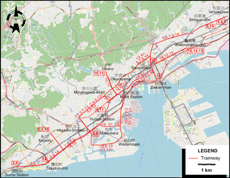
I created the above map by overlaying OpenStreetMap (OSM) maps with my own data. The underlying map data is © OpenStreetMap contributors, licensed under the Open Database License (ODbL).
Please note that the OSM map used as a template for this map corresponds to the situation at the time the map was downloaded and may show features that did not exist at the time the GS Tram Site is supposed to show. In particular, it may show bridges and highways that were built later.
TRAM ROUTES
Operator: 神戸市交通局 (Kōbe Municipal Transportation Bureau)
| 1 | 板宿 (Itayado) - 東尻池二 (Higashi-Shiriike-2) - 和田岬 (Wadamisaki) - 神戸駅前 (Kōbe Station) - 大倉山 (Ōkurayama) - 湊川公園 (Minatogawa-kōen) - 東尻池二 (Higashi-Shiriike-2) - 板宿 (Itayado) [Loop route, counterclockwise] |
| 2 | 板宿 (Itayado) - 東尻池二 (Higashi-Shiriike-2) - 湊川公園 (Minatogawa-kōen) - 大倉山 (Ōkurayama) - 神戸駅前 (Kōbe Station) - 和田岬 (Wadamisaki) - 東尻池二 (Higashi-Shiriike-2) - 板宿 (Itayado) [Loop route, clockwise] |
| 3 | 須磨駅 (Suma Station) - 鷹取町 (Takatori-chō) - 東尻池二 (Higashi-Shiriike-2) - 松原 (Matsubara) - 神戸駅前 (Kōbe Station) - 三宮 (Sannomiya) - 大倉山 (Ōkurayama) - 湊川公園 (Minatogawa-kōen) - 東尻池二 (Higashi-Shiriike-2) - 鷹取町 (Takatori-chō) - 須磨駅 (Suma Station) [Loop route, counterclockwise] |
| 4 | 須磨駅 (Suma Station) - 鷹取町 (Takatori-chō) - 東尻池二 (Higashi-Shiriike-2) - 湊川公園 (Minatogawa-kōen) - 大倉山 (Ōkurayama) - 三宮 (Sannomiya) - 神戸駅前 (Kōbe Station) - 松原 (Matsubara) - 東尻池二 (Higashi-Shiriike-2) - 鷹取町 (Takatori-chō) - 須磨駅 (Suma Station [Loop route, clockwise] |
| 5 | 石屋川 (Ishiyagawa) - 将軍通 (Shōgun-dōri) - 大倉山 (Ōkurayama) - 神戸駅前 (Kōbe Station) - 和田岬 (Wadamisaki) - 東尻池二 (Higashi-Shiriike-2) - 湊川公園 (Minatogawa-kōen) - 大倉山 (Ōkurayama) - 将軍通 (Shōgun-dōri) - 石屋川 (Ishiyagawa) [Loop route, clockwise] |
| 6 | 石屋川 (Ishiyagawa) - 将軍通 (Shōgun-dōri) - 三宮 (Sannomiya) - 神戸駅前 (Kōbe Station) - 兵庫駅 (Hyōgo Station) |
| 7 | 石屋川 (Ishiyagawa) - 将軍通 (Shōgun-dōri) - 大倉山 (Ōkurayama) - 湊川公園 (Minatogawa-kōen) - 東尻池二 (Higashi-Shiriike-2) - 和田岬 (Wadamisaki) - 神戸駅前 (Kōbe Station) - 大倉山 (Ōkurayama) - 将軍通 (Shōgun-dōri) - 石屋川 (Ishiyagawa) [Loop route, counterclockwise] |
| 8 | 税関前 (Zeikan-mae) - 三宮 (Sannomiya) - 大倉山 (Ōkurayama) - 湊川公園 (Minatogawa-kōen) - 東尻池二 (Higashi-Shiriike-2) |
| 9 | 将軍通 (Shōgun-dōri) - 三宮 (Sannomiya) - 神戸駅前 (Kōbe Station) - 湊川公園 (Minatogawa-kōen) - 東尻池二 (Higashi-Shiriike-2) |
| 10 | 脇浜町 (Wakinohama-chō) - 三宮 (Sannomiya) - 神戸駅前 (Kōbe Station) - 湊川公園 (Minatogawa-kōen) - 平野 (Hirano) |
| 11 | 兵庫駅 (Hyōgo Station) - 平野 (Hirano) |
| 12 | 脇浜町 (Wakinohama-chō) - 三宮 (Sannomiya) - 神戸駅前 (Kōbe Station) - 和田岬 (Wadamisaki) - 東尻池二 (Higashi-Shiriike-2) - 湊川公園 (Minatogawa-kōen) - 神戸駅前 (Kōbe Station) - 三宮 (Sannomiya) - 脇浜町 (Wakinohama-chō) [Loop route, clockwise] |
| 13 | 脇浜町 (Wakinohama-chō) - 三宮 (Sannomiya) - 神戸駅前 (Kōbe Station) - 湊川公園 (Minatogawa-kōen) - 東尻池二 (Higashi-Shiriike-2) - 和田岬 (Wadamisaki) - 神戸駅前 (Kōbe Station) - 三宮 (Sannomiya) - 脇浜町 (Wakinohama-chō) [Loop route, anticlockwise] |
| 14 | 将軍通 (Shōgun-dōri) - 大倉山 (Ōkurayama) - 湊川公園 (Minatogawa-kōen) - 東尻池二 (Higashi-Shiriike-2) - 鷹取町 (Takatori-chō) |
| 15 | 三宮 (Sannomiya) - 神戸駅前 (Kōbe Station) - 和田岬 (Wadamisaki) - 東尻池二 (Higashi-Shiriike-2) - 板宿 (Itayado) |
CHARACTERISTICS OF THE SYSTEM
NETWORK LENGTH
- Urban tramways: 35.6 km.
HISTORY
- Electric tramways: 5 Apr. 1910 - 13 March 1971.
- Subway: 13 March 1977 - today.
- Kobe New Transit (Automated guideway transit): 5 Feb. 1981 - today.
GAUGE
- Tramways: 1435 mm.
- Subway: 1435 mm.
SOURCES
- Demery, L.W., Forty, R., DeGroote, R. and Higgins, J.W. Electric railways of Japan - Vol.2: Central Japan. London: Light Rail Transit Association, 1985.
- 金治勉 (Kanaji, T.) 神戸市電が走った街 今昔 (City quarters through which Kobe's tramways ran - Past and present) Tokyo: JTB, 2001.
WIKIS
WEB SITES
Copyright Gabor Sandi 1998-2026
Disclaimer: Everything on this site was written and/or prepared at the author's discretion. The author has tried to be accurate where facts are presented, but this does not mean that these facts are necessarily accurate. People needing more reliable information should refer to appropriate sources presented, on the Internet or elsewhere, by authoritative professional or academic bodies.
To get in touch with the webmaster, send an e-mail to g_sandi at hotmail.com.
Flags on this site are from the FOTW Flags Of The World website.