VIDEOS
 |
 |
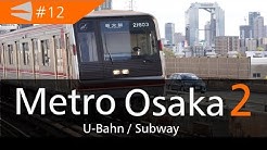 |
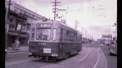
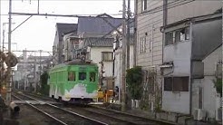
| Above: YouTubeCA video - 大阪市電3001形車内音(3007号) (Osaka 3001 series tram) Slides - Length: 3:46 mins. | Above: YouTubeCA video - 阪堺電車阪堺線PV (Hankai Tramway Hankai Line PV) - Length: 1:15 mins. | Above: YouTubeCA video - Metro Osaka 2 / Osaka Subway 8-Lines,JAPAN [2018] (Subway/U-Bahn) - Length: 12:39 mins. |
PHOTOS
 |
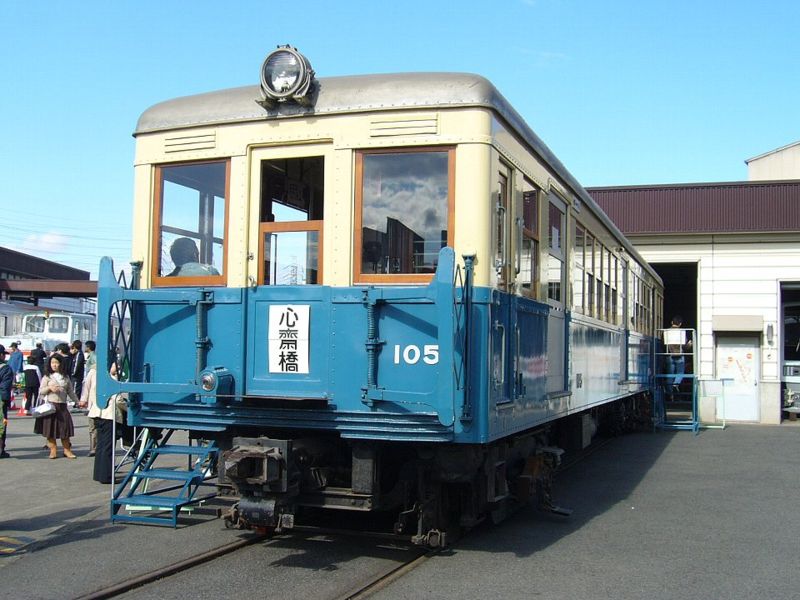 |
 |
MAP
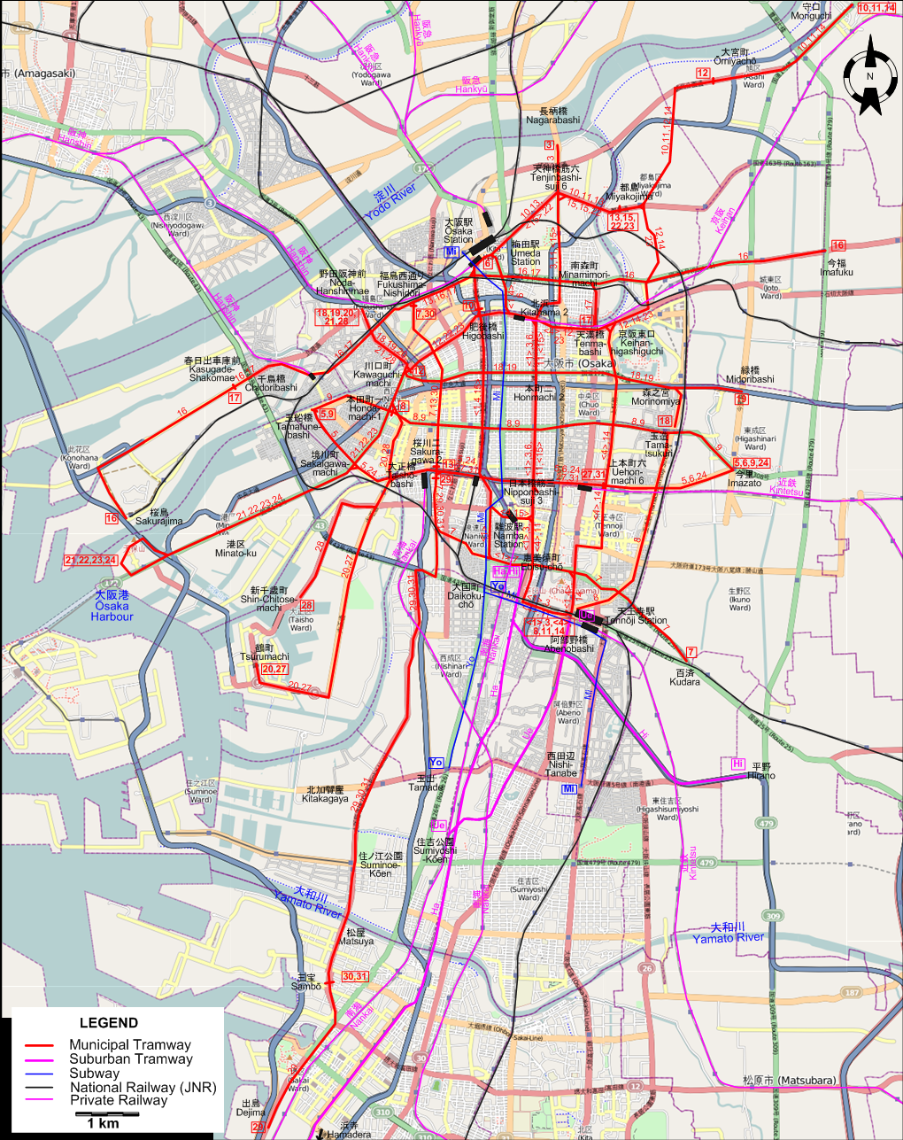
I created the above map by overlaying OpenStreetMap (OSM) maps with my own data. The underlying map data is © OpenStreetMap contributors, licensed under the Open Database License (ODbL).
Please note that the OSM map used as a template for this map corresponds to the situation at the time the map was downloaded and may show features that did not exist at the time the GS Tram Site is supposed to show. In particular, it may show bridges and highways that were built later.
ROUTES
Operator: 大阪市交通局 (Osaka Municipal Transportation Bureau)
URBAN TRAM ROUTES
| 1 | 阿部野 (Abenobashi) – 大国町 (Daikokuchō) - 肥後橋 (Higobashi) – 大阪駅 (Ōsaka Station) - 北浜二丁目 (Kitahama Nichōme) - 本町二丁目 (Honmachi Nichōme) - 日本橋筋三丁目 (Nipponbashi-suji Sanchōme) - 阿部野 (Abenobashi) [Circular route, both directions] |
| 3 | 阿部野 (Abenobashi) – 日本橋筋三丁目 (Nipponbashi-suji Sanchōme) - 本町二丁目 (Honmachi Nichōme) - 北浜二丁目 (Kitahama Nichōme) - 南森町 (Minamimori-machi) - 天神橋筋六 (Tenjinbashi-suji Rokuchōme) - 長柄橋 (Nagarabashi) |
| 4 | 阿部野 (Abenobashi) – 難波駅 (Namba Station) - 肥後橋 (Higobashi) – 大阪駅 (Ōsaka Station) - 北浜二丁目 (Kitahama Nichōme) - 天満橋 (Tenmabashi) - 京阪東口 (Keihan-higashiguchi) - 上本町六 丁目 (Uehonmachi Rokuchōme) - 阿部野 (Abenobashi) [Circular route, both directions] |
| 5 | 玉船橋 (Tamafunebashi) – 境川町 (Sakaigawa-machi) – 大正橋 (Taishō-bashi) - 桜川二丁目 (Sakuragawa Nichōme) - 日本橋筋三 (Nipponbashi-suji Sanchōme) - 上本町六 (Uehonmachi Rokuchōme) - 今里 (Imazato) |
| 6 | 大阪駅 (Ōsaka Station) - 北浜二丁目 (Kitahama Nichōme) - 本町二丁目 (Honmachi Nichōme) - 日本橋筋三丁目 (Nipponbashi-suji Sanchōme) - 上本町六 (Uehonmachi Rokuchōme) - 今里 (Imazato) |
| 7 | 福島西通り (Fukushima-Nishidōri) - 桜川二丁目 (Sakuragawa Nichōme) - 大国町 (Daikokuchō) - 百済 (Kudara) |
| 8 | 本田町一丁目 (Hondamachi-Itchōme) - 玉造 (Tamatsukuri) - 阿部野 (Abenobashi) |
| 9 | 玉船橋 (Tamafunebashi) – 本田町一丁目 (Hondamachi-Itchōme) - 玉造 (Tamatsukuri) - 今里 (Imazato) |
| 10 | 肥後橋 (Higobashi) – 大阪駅 (Ōsaka Station) - 天神橋筋六 (Tenjinbashi-suji Rokuchōme) - 都島 (Miyakojima) - 大宮町 (Ōmiyachō) - 守口 (Moriguchi) |
| 11 | 阿部野 (Abenobashi) – 日本橋筋三丁目 (Nipponbashi-suji Sanchōme) - 本町二丁目 (Honmachi Nichōme) - 北浜二丁目 (Kitahama Nichōme) - 南森町 (Minamimori-machi) - 天神橋筋六 (Tenjinbashi-suji Rokuchōme) - 都島 (Miyakojima) - 大宮町 (Ōmiyachō) - 守口 (Moriguchi) |
| 12 | 川口町 (Kawaguchimachi) - 肥後橋 (Higobashi) – 北浜二丁目 (Kitahama Nichōme) - 天満橋 (Tenmabashi) - 京阪東口 (Keihan-higashiguchi) - 都島 (Miyakojima) - 大宮町 (Ōmiyachō) |
| 13 | 桜川二丁目 (Sakuragawa Nichōme) - 福島西通り (Fukushima-Nishidōri) - 大阪駅 (Ōsaka Station) - 天神橋筋六丁目 (Tenjinbashi-suji Rokuchōme) - 都島 (Miyakojima) |
| 14 | 阿部野 (Abenobashi) – 上本町六 丁目 (Uehonmachi Rokuchōme) - 京阪東口 (Keihan-higashiguchi) - 都島 (Miyakojima) - 大宮町 (Ōmiyachō) - 守口 (Moriguchi) |
| 15 | 都島 (Miyakojima) - 天神橋筋六 (Tenjinbashi-suji Rokuchōme) - 南森町 (Minamimori-machi) - 北浜二丁目 (Kitahama Nichōme) - 本町二丁目 (Honmachi Nichōme) - 日本橋筋三丁目 (Nipponbashi-suji Sanchōme) - 難波駅 (Namba Station) - 肥後橋 (Higobashi) – 大阪駅 (Ōsaka Station) - 天神橋筋六 (Tenjinbashi-suji Rokuchōme) - 都島 (Miyakojima) [Circular route, both directions] |
| 16 | 桜島駅 (Sakurajima Station) - 春日出車庫前 (Kasugade-Shakomae) - 千鳥橋 (Chidoribashi) - 福島西通り (Fukushima-Nishidōri) - 南森町 (Minamimori-machi) - 今福 (Imafuku) |
| 17 | 春日出車庫前 (Kasugade-Shakomae) - 千鳥橋 (Chidoribashi) - 福島西通り (Fukushima-Nishidōri) - 南森町 (Minamimori-machi) - 天満橋 (Tenmabashi) |
| 18 | 野田阪神前 (Noda-Hanshinmae) - 川口町 (Kawaguchimachi) - 本町二丁目 (Honmachi Nichōme) - 森之宮 (Morinomiya) - 玉造 (Tamatsukuri) |
| 19 | 野田阪神前 (Noda-Hanshinmae) - 川口町 (Kawaguchimachi) - 本町二丁目 (Honmachi Nichōme) - 森之宮 (Morinomiya) - 緑橋 (Midoribashi) |
| 20 | 野田阪神前 (Noda-Hanshinmae) - 川口町 (Kawaguchimachi) - 本田町一丁目 (Hondamachi-Itchōme) - 大正橋 (Taishō-bashi) - 鶴町 (Tsurumachi) |
| 21 | 野田阪神前 (Noda-Hanshinmae) - 川口町 (Kawaguchimachi) - 本田町一丁目 (Hondamachi-Itchōme) - 境川町 (Sakaigawa-machi) - 港区 (Minato-ku) - 大阪港 (Ōsaka Harbour) |
| 22 | 都島 (Miyakojima) - 天神橋筋六丁目 (Tenjinbashi-suji Rokuchōme) - 大阪駅 (Ōsaka Station) - 肥後橋 (Higobashi) - 川口町 (Kawaguchimachi) - 本田町一丁目 (Hondamachi-Itchōme) - 境川町 (Sakaigawa-machi) - 港区 (Minato-ku) - 大阪港 (Ōsaka Harbour) |
| 23 | 都島 (Miyakojima) - 京阪東口 (Keihan-higashiguchi) - 天満橋 (Tenmabashi) - 肥後橋 (Higobashi) - 川口町 (Kawaguchimachi) - 本田町一丁目 (Hondamachi-Itchōme) - 境川町 (Sakaigawa-machi) - 港区 (Minato-ku) - 大阪港 (Ōsaka Harbour) |
| 24 | 今里 (Imazato) - 上本町六 (Uehonmachi Rokuchōme) - 日本橋筋三 (Nipponbashi-suji Sanchōme) - 桜川二丁目 (Sakuragawa Nichōme) - 大正橋 (Taishō-bashi) - 境川町 (Sakaigawa-machi) - 港区 (Minato-ku) - 大阪港 (Ōsaka Harbour) |
| 27 | 上本町六 (Uehonmachi Rokuchōme) - 日本橋筋三 (Nipponbashi-suji Sanchōme) - 桜川二丁目 (Sakuragawa Nichōme) - 大正橋 (Taishō-bashi) - 鶴町 (Tsurumachi) |
| 28 | 野田阪神前 (Noda-Hanshinmae) - 川口町 (Kawaguchimachi) - 本田町一丁目 (Hondamachi-Itchōme) - 大正橋 (Taishō-bashi) - 新千歳町 (Shin-Chitose-machi) |
| 29 | 桜川二丁目 (Sakuragawa Nichōme) - 北加賀屋 (Kitakagaya) - 住の江公園 (Suminoe-Kōen) - 松屋 (Matsuya) - 三宝車庫前 (Sambō-Shakomae) - 出島 (Dejima) |
| 30 | 福島西通り (Fukushima-Nishidōri) - 桜川二丁目 (Sakuragawa Nichōme) - 北加賀屋 (Kitakagaya) - 住の江公園 (Suminoe-Kōen) - 松屋 (Matsuya) - 三宝車庫前 (Sambō-Shakomae) |
| 31 | 上本町六 (Uehonmachi Rokuchōme) - 日本橋筋三 (Nipponbashi-suji Sanchōme) - 桜川二丁目 (Sakuragawa Nichōme) - 北加賀屋 (Kitakagaya) - 住の江公園 (Suminoe-Kōen) - 松屋 (Matsuya) - 三宝車庫前 (Sambō-Shakomae) |
Subway and suburban routes in Osaka were identified by line names. The two-letter abbreviations used on the maps and below are strictly for convenience, and were never used by the operators.
SUBWAY ROUTES
| Mi | 御堂筋線 | Midōsuji Line | 梅田 (Umeda) - なんば (Namba) - 大国町 (Daikokuchō) - 天王寺 (Tennōji) - 西田辺 (Nishitanabe) |
| Yo | 四つ橋線 | Yotsubashi Line | 大国町 (Daikokuchō) - 玉出 (Tamade) |
Operator: 南海電気鉄道 (Nankai Railway)
SUBURBAN TRAM ROUTES
| Ue | 上町線 | Uemachi Line | 天王寺駅 (Tennōji Station) - 住吉公園 (Sumiyoshi-Kōen) |
| Ha | 阪堺線 | Hankai Line | 恵美須町 (Ebisu-chō) - 浜寺 (Hamadera) |
| Hi | 平野線 | Hirano Line | 恵美須町 (Ebisu-chō) - 平野 (Hirano) |
CHARACTERISTICS OF THE SYSTEM
NETWORK LENGTH
- Urban tramway: 116 km.
- Suburban tramway: 25 km.
- Subway : 14 km.
HISTORY
- Municipal tramway: 1903 - 31 Mar. 1969.
- Suburban tramway (horse-drawn): 30 Sept. 1900 - 1 Oct. 1910; (electric): 1 Oct. 1910 - today.
- Municipal subway: 20 May 1933 - today.
- Elevated guideway LRT (New Tram): 16 March 1981 - today.
- Monorail: 1 June 1990 - today.
GAUGE
- Municipal tramway: 1435 mm.
- Suburban tramway: 1435 mm.
- Municipal subway: 1435 mm.
SOURCES
- Demery, L.W., Forty, R., DeGroote, R. and Higgins, J.W. Electric railways of Japan - Vol.2: Central Japan. London: Light Rail Transit Association, 1985.
- Forty, R. and Higgins, J.W. "Japan today (Part 5: Osaka and Kyoto)", Modern Tramway and Light Rail Transit, Nov. 1977 (40:479), p.376-387.
- 原口隆行 (Haraguchi, T.) 日本の路面電車 I (Japan's Street Railways, Pt.I) Tokyo: JTB, 2000.
- 辰巳博、福田静二 (Tatsumi, H. & Fukuda, S.) 大阪市電が走った街今昔 (Ōsaka City tramways - Yesterday and today). Tokyo: JTB, 2000.
WIKIS
- 阪堺電車阪堺線 (Hankai Line)
- 阪堺電気軌道 (Hankai Tramway)
- 阪堺電気軌道上町線 (Hankai Uemachi Line)
- 南海電気鉄道株式会社 (Nankai Electric Railway)
- 南港ポートタウン線 (Nankō Port Town Line)
- 大阪市電 (Ōsaka City trams)
- 大阪市営地下鉄 (Osaka Metro)
- 大阪モノレール (Osaka Monorail)
- 大阪市交通局 (Osaka Municipal Transportation Bureau)
WEB SITES
- 阪堺電車 (Hankai Densha)
- 南海電気鉄道 (Nankai Railway)
- Osaka (on UrbanRail.Net)
- 大阪市営地下鉄 (Osaka Metro)
- 市内電車いろいろ (Various things about the city tramways)
Copyright Gabor Sandi 1998-2026
Disclaimer: Everything on this site was written and/or prepared at the author's discretion. The author has tried to be accurate where facts are presented, but this does not mean that these facts are necessarily accurate. People needing more reliable information should refer to appropriate sources presented, on the Internet or elsewhere, by authoritative professional or academic bodies.
To get in touch with the webmaster, send an e-mail to g_sandi at hotmail.com.
Flags on this site are from the FOTW Flags Of The World website.