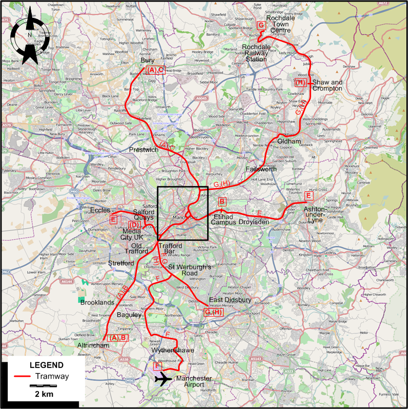
INSET: CENTRAL MANCHESTER

I created the above maps by overlaying OpenStreetMap (OSM) maps with my own data. The underlying map data is © OpenStreetMap contributors, licensed under the Open Database License (ODbL).
Please note that the OSM maps used as a template for these maps corresponds to the situation at the time the map was downloaded and may show features that did not exist at the time the GS Tram Site is supposed to show. In particular, it may show bridges and highways that were built later.
TRAM ROUTES
Operator: The RATP Group, on behalf of Transport for Greater Manchester (TfGM)
| A | Altrincham - Bury | Altrincham - Brooklands - Stretford - Old Trafford - Trafford Bar - Cornbrook - Deansgate-Castlefield - Piccadilly Gardens - Victoria - Prestwich - Bury [Peak only] |
| B | Altrincham - Etihad Campus | Altrincham - Brooklands - Stretford - Old Trafford - Trafford Bar - Cornbrook - Deansgate-Castlefield - Piccadilly Gardens - Piccadilly - Etihad Campus |
| C | Bury - Piccadilly | Bury - Prestwich - Victoria Station - Piccadilly Gardens - Piccadilly |
| D | Media City UK - Piccadilly | Media City UK - Cornbrook - Deansgate-Castlefield - Piccadilly Gardens - Piccadilly [Peak only] |
| E | Eccles - Ashton-under-Lyne | Eccles - Salford Quays) - (Off-peak only: Media City UK) - Cornbrook - Deansgate-Castlefield - Piccadilly Gardens - Piccadilly - Etihad Campus - Droylsden - Ashton-under-Lyne |
| F | Manchester Airport - Deansgate-Castlefield | Manchester Airport - Wythenshawe - Baguley - St Werburgh's Road - Trafford Bar - Cornbrook - Deansgate-Castlefield |
| G | Rochdale Town Centre - East Didsbury | Rochdale Town Centre - Rochdale Station - Shaw and Crompton - Oldham - Failsworth - Victoria - Exchange Square - Deansgate-Castlefield - Cornbrook - Trafford Bar - St Werburgh's Road - East Didsbury |
| H | Shaw and Crompton - East Didsbury | Shaw and Crompton - Oldham - Failsworth - Victoria - Exchange Square - Deansgate-Castlefield - Cornbrook - Trafford Bar - St Werburgh's Road - East Didsbury [Peak only] |
CHARACTERISTICS OF THE SYSTEM
NETWORK LENGTH
- Tramway (Metrolink): 93.8 km.
HISTORY
Tramways
- Horse-powered tramways: 17 May 1877 - 1903.
- Steam-powered tramways: 1882 - 1905.
- First-generation electric tramways: 7 June 1901 - 10 Jan. 1949 (in Bury until Feb. 1949 and in Stockport until 25 Aug. 1951).
- Revived tramway (electric overhead): 20 July 1992 – today.
GAUGE
- Tramways / Metrolink: 1435 mm.
TRAM PRESERVATION
The Museum of Transport , in Smedley, just north of Victoria Station, has a horse-drawn tram, two early electric trams and the prototype Metrolink tram from the early 1990s.
SOURCES
- Bett, W.H. & Gillham, J.C. Great British tramway networks. London: Light Railway Transport League, 1962.
- "MetroLink: Next stop ... Trafford Park", Tramways & Urban Transit, Aug. 2019 (82: 980), p.294-296.
- "Metrolink on the move", Tramways & Urban Transit, July 2008 (71: 847), 24p. supplement.
- Symons, J. & Johnston, H. "Manchester: The 20 year wait for a tram!", Tramways & Urban Transit, July 2002 (65: 775), p.248-252.
- Wilson, A. "A brief history of the Manchester tramways", The Modern Tramway. Nov. 1941 (4: 47), p.124-125. and Dec. 1941 (4: 48), p.140-141.
- Pulling, N. "Systems Factfile Special: Metrolink, Manchester, UK", Tramways & Urban Transit, July 2011 (74: 883), p.263-268.
- Pulling, N. "Systems Factfile No. 165: Manchester, United Kingdom", Tramways & Urban Transit, July 2021 (84: 1003), p.284-289.
- Yearsley, I. The Manchester tram. Huddersfield: The Advertiser Press,1962.
- Young, A.P. "Britain's first new generation tramway", Light Rail & Modern Tramway, July 1992 (55: 655), p.173-179.
WIKIS
- Greater Manchester Passenger Transport Executive
- History of Manchester Metrolink
- Manchester Corporation Tramways
- Manchester Metrolink
- Museum of Transport, Greater Manchester
WEB SITES
Copyright Gabor Sandi 1998-2026
Disclaimer: Everything on this site was written and/or prepared at the author's discretion. The author has tried to be accurate where facts are presented, but this does not mean that these facts are necessarily accurate. People needing more reliable information should refer to appropriate sources presented, on the Internet or elsewhere, by authoritative professional or academic bodies.
To get in touch with the webmaster, send an e-mail to g_sandi at hotmail.com.
Flags on this site are from the FOTW Flags Of The World website.