
VIDEOS
 |
 |
 |
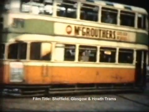
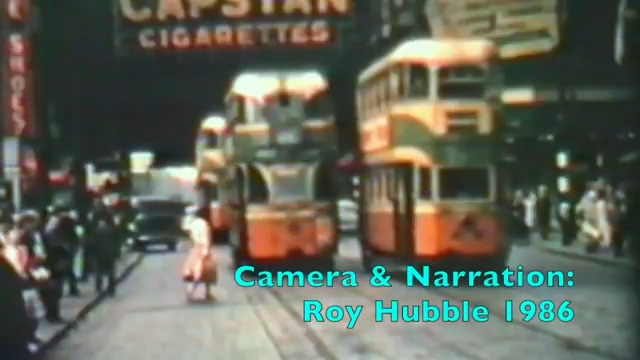
| Above: YouTubeCA video – Glasgow Trams on Sauchiehall Street in April 1959 – Length: 1:30 mins. | Above: YouTubeCA video – Glasgow Trams 1959 – Length: 33:09 mins. | Above: YouTubeCA video – The Glasgow Subway: 1896-1977, & 1980 onwards – Length: 23:53 mins. |
PHOTOS
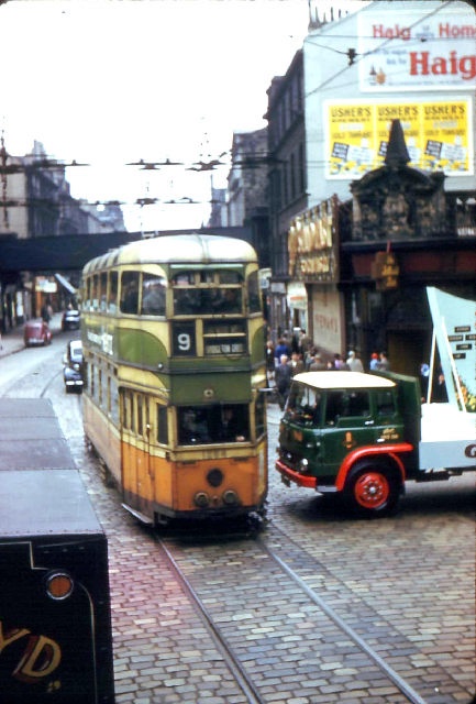 |
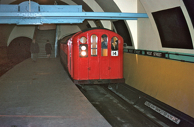 |
MAPS
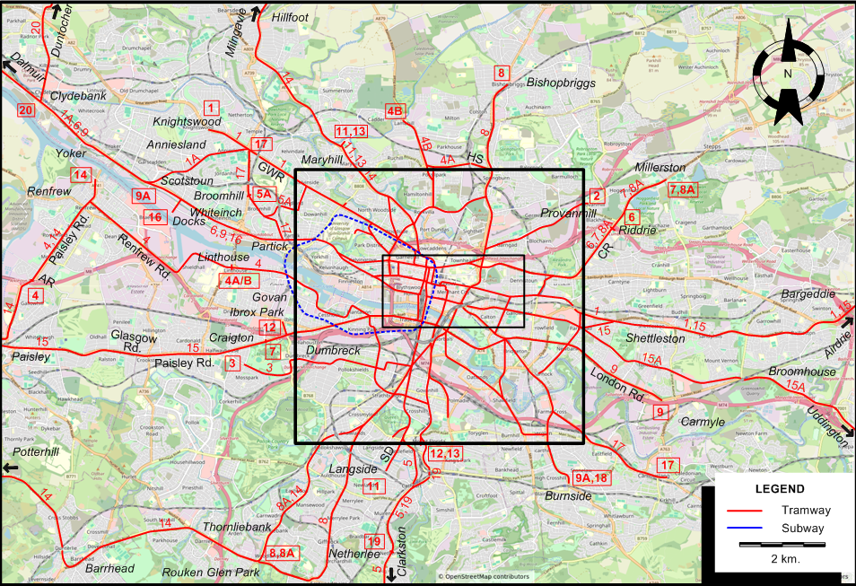
INSET: GLASGOW - CENTRAL AREA
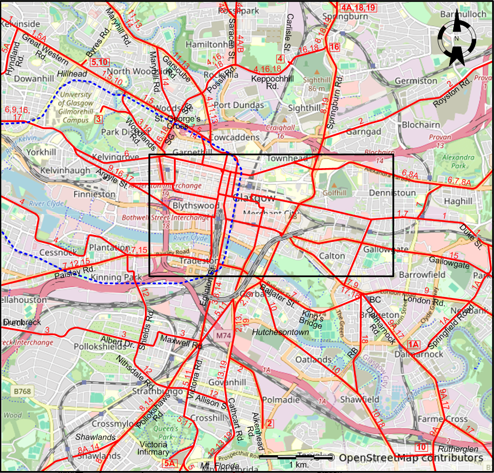
INSET: GLASGOW - CITY CENTRE
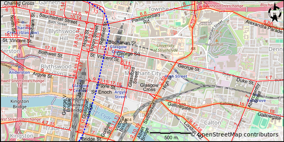
I created the above maps by overlaying OpenStreetMap (OSM) maps with my own data. The underlying map data is © OpenStreetMap contributors, licensed under the Open Database License (ODbL).
Please note that the OSM maps used as a template for these maps corresponds to the situation at the time the map was downloaded and may show features that did not exist at the time the GS Tram Site is supposed to show. In particular, it may show bridges and highways that were built later.
ABBREVIATIONS ON THE MAPS
| AR | Arkleston Road | HS | Hawthorn St. |
| BC | Bridgeton Cross | RB | Rutherglen Bridge |
| CR | Cumbernauld Road | SD | Sinclair Drive |
| GWR | Great Western Road | SG | St. George's Rd. |
ROUTES
TRAM ROUTES
Operator: Glasgow Corporation Tramways
| 1 | Knightswood Cross - Great Western Road - St George's Cross - Sauchiehall Street - Hope St. - St. Vincent St. - George Square (Queen Street Station) - George Street - Duke Street (Dennistoun) - Shettleston - Bargeddie - Coatbridge - Coatdyke - Airdrie (Clark Street) |
| 1A | Dalmuir (Dumbarton Road) - Clydebank - Yoker - Anniesland - Great Western Road - St George's Cross - Sauchiehall Street - George Square (Queen Street Station) - George Street - Duke Street (Dennistoun) - Springfield Road - Dalmarnock (Dalmarnock Road) |
| 2 | Polmadie (Aikenhead Road) - Gorbals (Crown Street) - Albert Bridge - Glasgow Cross - Saltmarket - High St. - Garngad - Germiston - Provanmill (Royston Road) |
| 3 | Mosspark - Dumbreck - Pollokshields - Albert Drive - Maxwell Road - Eglinton Street - Glasgow Bridge - Jamaica St. - [Argyle St. - Hope St. ] [back: Union Street] - Sauchiehall Street - Charing Cross - Woodlands Road - University of Glasgow (Gibson St.) |
| 4 | Renfrew (Paisley Road from Arkleston Road) - Renfrew Road - Linthouse - Govan - Cessnock - Plantation - Paisley Rd. - Tradeston - George V Bridge - Hope Street - Garscube Road - Possil Road - Keppochhill Rd. - Keppochhill (Carlisle Street) |
| 4A | Linthouse - Govan - Cessnock - Plantation - Paisley Rd. - Tradeston - George V Bridge - Hope Street - Garscube Road - Possil Road - Saracen St. - Hawthorn St. - Springburn |
| 4B | Linthouse - Govan - Cessnock - Plantation - Paisley Rd. - Tradeston - George V Bridge - Hope Street - Garscube Road - Possil Road - Saracen St. - Balmore Rd. - Lambhill |
| 5 | Clarkston (Busby Road) - Stamperland - Netherlee - Muirend - Cathcart - Battlefield - Crosshill - Victoria Road - Gorbals (Gorbals Street) - Victoria Bridge - Glassford Street - George Square - St. Vincent St. - Renfield Street - Great Western Road - Hillhead (Byres Road) |
| 5A | Victoria Infirmary - Crosshill - Victoria Road - Gorbals (Gorbals Street) - Victoria Bridge - Glassford Street - George Square - St. Vincent St. - Renfield Street - Great Western Road - Hyndland Rd. - Broomhill |
| 6 | Dalmuir (Dumbarton Road) - Clydebank - Scotstoun - Whiteinch - Partick - Kelvingrove - Charing Cross - Sauchiehall Street - Parliamentary Road - Alexandra Parade - Haghill (Cumbernauld Road) - Riddrie (Smithycroft Road) |
| 7 | Craigton (Jura Street) - Paisley Road - Kingston - Tradeston - Ballater Street - King's Bridge - Glasgow Green - Bridgeton Cross - London Road - Abercromby Street - Duke St. - Dennistoun - Haghill (Cumbernauld Road) - Riddrie - Blackhill (Cumbernauld Road) - Millerston (Station Road) |
| 8 | Rouken Glen Park - Giffnock (Fenwick Road) - Auldhouse (Kilmarnock Road) - Shawlands - Pollokshaws Rd. - Eglinton Street - Glasgow Bridge - Jamaica St. - [Argyle St. - Hope St. ] [back: Union Street] - Sauchiehall Street - Parliamentary Road - Springburn Road - Springburn - Bishopbriggs |
| 8A | Rouken Glen Park - Thornliebank - Shawlands - Pollokshaws Rd. - Eglinton Street - Glasgow Bridge - Jamaica St. - [Argyle St. - Hope St. ] [back: Union Street] - Sauchiehall Street - Parliamentary Road - Haghill (Cumbernauld Road) - Riddrie (Smithycroft Road) - Blackhill (Cumbernauld Road) - Millerston (Station Road) |
| 9 | Dalmuir (Dumbarton Road) - Clydebank - Scotstoun - Whiteinch - Partick - Yorkhill - Argyle Street - Glasgow Cross - London Road - Carmyle |
| 9A | Scotstoun - Whiteinch - Yorkhill - Finnieston - Argyle Street - Glasgow Cross - London Road - Bridgeton Cross - Dalmarnock Rd. - Farme Cross - Burnside |
| 10 | Hillhead (Byres Road) - Great Western Road - Woodlands Road - Charing Cross - Sauchiehall Street - Hope Street - Argyle Street - Glasgow Cross - Albert Bridge - Gorbals (Crown Street) - Hutchesontown - Oatlands - Shawfield - Rutherglen (Main Street) |
| 11 | Langside - Sinclair Drive - Victoria Road - St Andrew's Cross - Gorbals Street - Victoria Bridge - Glassford Street - George Square - St. Vincent St. - Renfield Street - Garscube Road - Maryhill Rd. - Maryhill (Lochburn Rd.) |
| 12 | Ibrox Park (Broomloan Road) - Paisley Road - Kinning Park - Shields Road - Nithsdale Road - Allison Street - Cathcart Road - Cathkin Park - Mount Florida (Clincart Road) |
| 13 | Mount Florida (Clincart Road) - Cathkin Park - Cathcart Road - Govanhill - Gorbals Street - Victoria Bridge - Glassford Street - George Square - St. Vincent St. - Renfield Street - Garscube Road - Maryhill Rd. - Maryhill (Lochburn Rd.) |
| 14 | Renfrew (Ferry Road) - Paisley Road - Paisley - Potterhill - Barrhead - Rouken Glen Park - Thornliebank - Shawlands - Pollokshaws Rd. - Eglinton Street - Glasgow Bridge - Jamaica St. - [Argyle St. - Hope St. ] [back: Union Street] - Sauchiehall Street - St George's Cross - Maryhill Road - Maryhill - Hillfoot - Milngavie (Main Street) |
| 15 | Paisley - Glasgow Road - Paisley Road - Kingston - Tradeston - Glasgow Bridge - Jamaica At. - Argyle Street - Trongate - Glasgow Cross - Gallowgate - Shettleston - Bargeddie - Coatbridge - Coatdyke - Airdrie (Clark Street) |
| 15A | Paisley - Glasgow Road - Paisley Road - Kingston - Tradeston - Glasgow Bridge - Jamaica At. - Argyle Street - Trongate - Glasgow Cross - Gallowgate - Tollcross - Broomhouse - Uddington |
| 16 | Docks - Whiteinch - Partick - Yorkhill - Argyle St. - St Vincent St. - North Street - Charing Cross - St. George's Road - Possil Road - Keppochhill Rd. - Springburn Road |
| 17 | Anniesland (Crow Road) - Jordanhill - Broomhill - Partick - Yorkhill - Argyle Street - Finnieston - St. Vincent Street - Hope Street - Argyle St. - Glasgow Cross - London Road - Bridgeton Cross - Dalmarnock Rd. - Farme Cross - Eastfield - Cambuslang (Main Street / Clydeford Road) |
| 18 | Burnside - Rutherglen - Shawfield - Rutherglen Bridge - Bridgeton Cross - London Road - Glasgow Cross - Argyle Street - Hope Street - Bothwell Street - Elmbank Street - Charing Cross - St. George's Road - Possil Rd. - Keppochhill Rd. - Springburn Road - Springburn |
| 19 | Netherlee - Muirend - Cathcart - Mount Florida - Cathcart Road - Gorbals (Crown Street) - Albert Bridge - Saltmarket - Glasgow Cross - High Street - Springburn Road - Springburn - |
| 20 | Clydebank (Glasgow Road) - Kilbowie Road - Radnor Park - Duntocher |
Note (1): Modified routes (e.g. 4A/B) are only labelled on the map when they are different from the unmodified route.
Note (2): The route network shown above does not include the special tram routes operated during the Empire Exhibition, 3 May - 29 Oct. 1938.
SUBWAY (UNDERGROUND) ROUTE
Operator: Glasgow Corporation
| Buchanan St. - St. George’s Cross - Hillhead - Partick - Govan - Cessnock - Kinning Park - Bridge St. - St. Enoch - Buchanan St. [Circular route, both directions] |
CHARACTERISTICS OF THE SYSTEM
NETWORK LENGTH
- Tramway: ca. 160 km.
- Subway (Underground): 10.5 km.
HISTORY
Tramways
- Horse tramway: 19 Aug. 1872 - Apr. 1902
- Electric tramway: 13 Oct. 1898 - 4 Sept. 1962
- Subway (Underground railway): 14 Dec. 1896 - 30 Nov. 1935 (cable); March 1935 - today (electric)
GAUGE
- Tramways: 1416 mm.
- Subway (Underground0): 1219 mm.
SOURCES
- Coonie, I.M. "The Glasgow Coronations, Part 2" Modern Tramway, Nov. 1978 (41: 491), p.366-372.
- Foster, R. "Multi-modal ambitions for Glasgow" Tramways & Urban Transit, June 2016 (89: 1062), p. 222-224
- "Glasgow Corporation tramway services" The Modern Tramway, Sept. 1946 (9: 105), p.78
- "Glasgow Subway: Creating the UK's first driverless railway" Tramways & Urban Transit, Nov. 2018 (81: 971), p. 415-421
WIKIS
WEB SITES
- Glasgow Corporation Transport 1274 on the site of the Seashore Trolley Museum (Kennebunkport, ME, USA)
- SPT - Subway
Copyright Gabor Sandi 1998-2026
Disclaimer: Everything on this site was written and/or prepared at the author's discretion. The author has tried to be accurate where facts are presented, but this does not mean that these facts are necessarily accurate. People needing more reliable information should refer to appropriate sources presented, on the Internet or elsewhere, by authoritative professional or academic bodies.
To get in touch with the webmaster, send an e-mail to g_sandi at hotmail.com.
Flags on this site are from the FOTW Flags Of The World website.