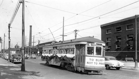
PHOTO
 |
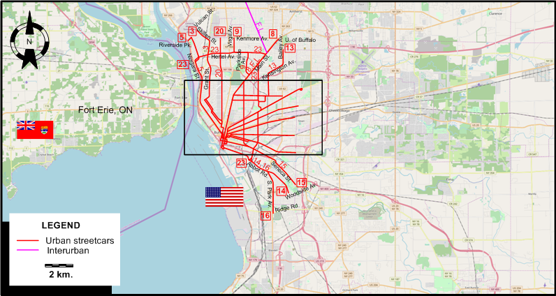
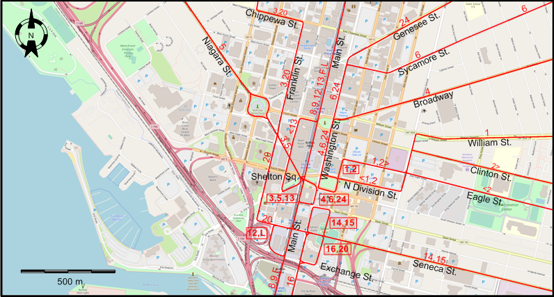
MAPS
INSET: CENTRAL BUFFALO
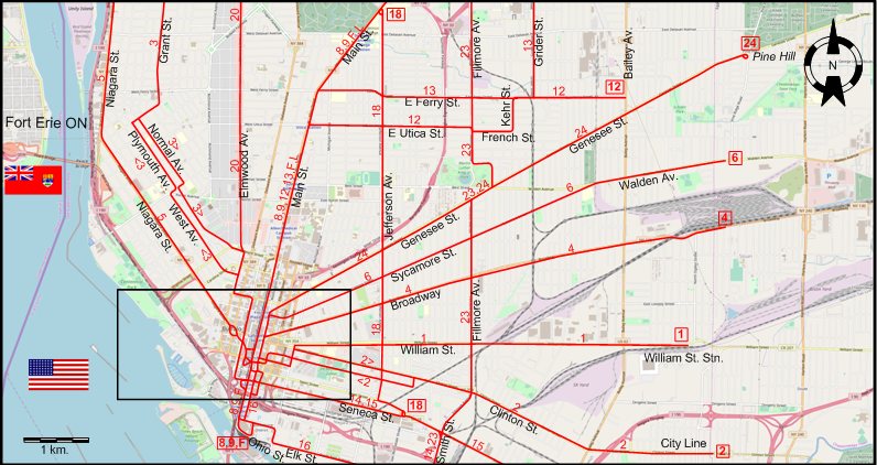
INSET: DOWNTOWN BUFFALO
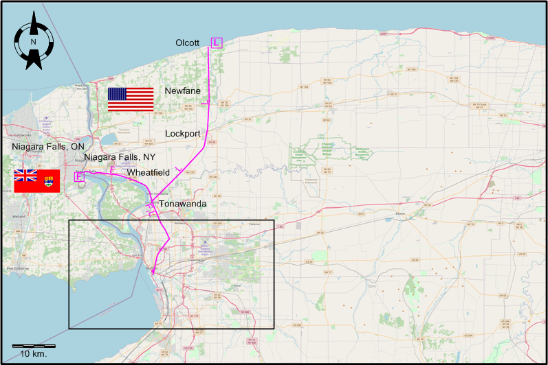
INSET: BUFFALO AND AREA (WITH ONLY INTERURBANS SHOWING)
I created the above maps by overlaying OpenStreetMap (OSM) maps with my own data. The underlying map data is © OpenStreetMap contributors, licensed under the Open Database License (ODbL).
Please note that the OSM maps used as a template for these maps corresponds to the situation at the time the map was downloaded and may show features that did not exist at the time the GS Tram Site is supposed to show. In particular, it may show bridges and highways that were built later.
DISCONTINUATION DATES OF STREETCAR TRACKS BETWEEN OCT. 1935 AND 1 JULY 1950 (affected route numbers in parentheses).
- 1936-1938: Grant St. (3); Niagara St. (5); Smith St. (14); Elmwood Av. (20)
- 1941 Apr. 19: William St. (1); Jefferson Av. (18)
- 1941 Sept.: Seneca St. (15, earlier also 14); Elk St. - Abbot Rd. - S. Park Av. - Ridge Rd. (16)
- 1947 Feb. 6: E Utica St. - French St. - E Ferry St. (12)
- 1948 Feb. 20: Clinton St. (2); Sycamore St. (6)
- 1950 June 19: Main (8,9); Parkside - Parkside Av. - Virgil Av. (9); E Ferry St. - Grider St. - Kensington Av. - Bailey Av. (13)
- 1950 July 1: Broadway (4); Fillmore Av. - Hertel Av. (23); Genesee St. (24)
ROUTES
BUFFALO STREETCAR ROUTES
Operator: International Railway Company (IRC)
| 1 | William | Ellicot St. - William St. - William St. Stn. |
| 2 | Clinton | Ellicot St. - Clinton St. [back: Eagle St.] - Clinton St. - City Line |
| 3 | Grant | Shelton Square - Niagara St. - Franklin St. - Chippewa St. - West Av. [back: Plymouth Av.] - Grant St. - Skillen St. - Vulcan St. |
| 4 | Broadway | N Division St. - Washington St. - Broadway |
| 5 | Niagara | Shelton Square - Niagara St. - Riverside Pk. |
| 6 | Sycamore | N Division St. - Washington St. - Sycamore St. - Walden Av. - City Line |
| 8 | Main | Ohio St. - Main St. - University of Buffalo |
| 9 | Kenmore | Ohio St. - Main St. - Parkside Av. - Virgil Av. - Kenmore Av. |
| 12 | East Utica | Exchange St. - Main St. - E Utica St. - French St. - E Ferry St. - Bailey Av. |
| 13 | Kensington | Shelton Square - Main St. - E Ferry St. - Grider St. - Kensington Av. - Bailey Av. |
| 14 | Abbott Road | Washington St. - Seneca St. - Smith St. - Abbot Rd. - Woodside Av. |
| 15 | Seneca | Washington St. - Seneca St. - City Line |
| 16 | South Park | Seneca St. - Washington St. - Elk St. - Abbot Rd. - S. Park Av. - Ridge Rd. |
| 18 | Jefferson | Main St. - Jefferson Av. - Seneca St. |
| 20 | Elmwood | Exchange St. - Seneca St. - Franklin St. - Chippewa St. - Elmwood Av. - Kenmore Av. |
| 23 | Fillmore/Hertel | Abbot Rd. - Smith St. - Fillmore Av. - Main St. - Hertel Av. - Niagara St. |
| 24 | Genesee | N Division St. - Washington St. - Genesee St. - Pine Hill |
INTERURBAN ROUTES
Operator: International Railway Company (IRC)
| F | Buffalo-Niagara Falls High Speed Line | Ohio St. - Main St. - ROW - Tonawanda - Wheatfield - Niagara Falls (NY) |
| L | Buffalo, Lockport and Olcott Beach Railway | Exchange St. - Main St. - ROW - Tonawanda - Lockport - Newfane - Olcott |
CHARACTERISTICS OF THE SYSTEM
NETWORK LENGTH
- Streetcar network: ? km.
- Interurbans: ? km.
HISTORY
- Streetcars (traditional): (horse-powered) 1860 - ; (electric) 1888 - 1 July 1950.
- Interurbans: 1895 - 20 Aug. 1937.
- Modern light rail: 9 Oct. 1984 - today.
GAUGE
- Streetcars & interurbans: 1435 mm.
SOURCES
- Bregger, D.D. Buffalo's historic streetcars and buses. Charleston (SC): Arcadia, 2008.
- Sellin, M.V. "Light rapid transit in Buffalo" Modern Tramway & Light Rail Transit, July 1985 (48: 571), p.228-231.
- Taplin, M.R. Tramways of North America, including rapid transit [Tramway Handbooks No.4] Hassocks (West Sussex, England): Light Rail Transit Association, 1981.
WIKIS
- Buffalo Metro Rail
- International Railway (New York–Ontario)
- Interurban railways (on the Chicago Transit & Railfan site)
- List of routes of City of Buffalo streetcars
WEB SITES
- International Railway Company - Buffalo Streetcar and Bus Guide, Oct. 1935
- NFTA Metro
- Niagara Falls Info: Niagara Falls, USA Streetcars
- OpenStreetMap - Relation: Buffalo-Niagara Falls High-Speed Line (1403975)
Special thanks to Russell Powers from Denver CO for information on the history of the Buffalo system.
Copyright Gabor Sandi 1998-2026
Disclaimer: Everything on this site was written and/or prepared at the author's discretion. The author has tried to be accurate where facts are presented, but this does not mean that these facts are necessarily accurate. People needing more reliable information should refer to appropriate sources presented, on the Internet or elsewhere, by authoritative professional or academic bodies.
To get in touch with the webmaster, send an e-mail to g_sandi at hotmail.com.
Flags on this site are from the FOTW Flags Of The World website.