MAPS
THE HOUSTON AREA

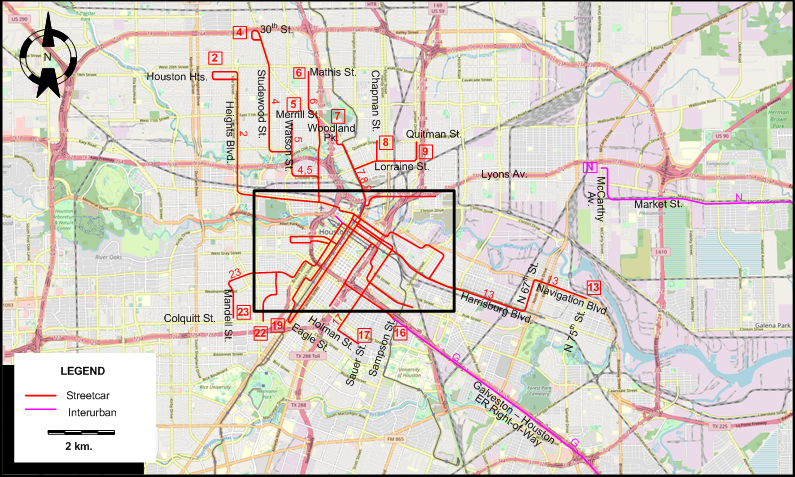
HOUSTON
INSET: CENTRAL HOUSTON
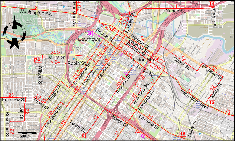
I created the above maps by overlaying OpenStreetMap (OSM) maps with my own data. The underlying map data is © OpenStreetMap contributors, licensed under the Open Database License (ODbL).
Please note that the OSM maps used as a template for these maps corresponds to the situation at the time the map was downloaded and may show features that did not exist at the time the GS Tram Site is supposed to show. In particular, it may show bridges and highways that were built later.
ROUTES
STREETCAR ROUTES
Operator: Houston Electric Co.
All routes originated downtown, but streetcars were mostly through-lined between two routes and it is not possible to assign downtown terminuses to them.
| 2 | Ervay | Downtown - Washington Av. - Heights Blvd. - Houston Hts. |
| 4 | Studewood | Downtown - Washington Av. - Houston Av. - Studewood St. - 30th St. |
| 5 | Watson | Downtown - Washington Av. - Houston Av. - Watson St. - Merrill St. |
| 6 | Myrtle | Downtown - Washington Av. - Houston Av. - Mathis St. |
| 7 | North Main | Downtown - North Main St. - Woodland Park |
| 8 | Chapman | Downtown - North Main St. - Chapman St. (to Morris St.) |
| 9 | North Side | Downtown - North Main St. - Lorraine St. - Quitman St. |
| 11 | Nance | Downtown - North Main St. - Nance St. - Gregg St. |
| 12 | Franklin | Downtown - Franklin St. - Canal St. - Engelke St. - Milby St. - Harrisburg Blvd. |
| 13 | Port Houston | Downtown - Preston St. [back: Congress St.] - Harrisburg Blvd. - N 67th St. [N Cesar Chavez Blvd.] - Navigation Blvd. - N 75th St. |
| 15 | Leeland | Downtown - Texas Av. - Hutchins Av. - Leeland St. - Milby St. |
| 16 | Pierce | Downtown - Texas Av. - Jackson St. - Pierce St. - Sampson St. |
| 17 | Dowling | Downtown - Preston St. [back: Congress St.] - Dowling St. [Emancipation Av.] - Holman St. - Sauer St. |
| 18 | La Branch | Downtown - Texas Av. - Jackson St. - Tuam St. |
| 19 | South End | Downtown - Fannin St. - McGowen St. - Louisiana St. - Eagle St. |
| 22 | Montrose | Downtown - Louisiana St. - Gray St. - Bagby St. - Tuam St. - Fairview St. - Taft St. - Hawthorne St. - Roseland St. - W. Main St. |
| 23 | Mondell | Downtown - Louisiana St. - Gray St. - Bagby St. - Tuam St. - Fairview St. - Mandell St. - Colquitt St. |
| 24 | San Felipe | Downtown - Travis St. - Robin St. [back: Dallas St.] - Wilson St. |
Route numbers are for convenience only; they were not used by the operator.
INTERURBAN ROUTES
Operator: Galveston-Houston Electric Railway
| G | Galveston Interurban | Downtown (Brazos St.) - Texas Av. - Jackson St. - Pierce St. - Galveston-Houston ER Right-of-Way - Galveston |
Operator: Houston North Shore Railway
| N | HNS | McCarty Av. - Market St. - Garth - Coady - Baytown - Goose Creek Stn. |
CHARACTERISTICS OF THE SYSTEM
NETWORK LENGTH
- Streetcar lines: ? km.
- Interurban line (Galveston-Houston Electric Railway): 80 km.
- Interurban line (Houston North Shore Railway): 32 km.
HISTORY
- Mule-drawn streetcars: 1868; 2 May 1874 - ?.
- Electric streetcars (1st generation): 15 June 1891 - 9 June 1940.
- Electric interurbans (Galveston-Houston Electric Railway): 5 Dec. 1911 - 31 Oct. 1936.
- Electric interurbans (Houston North Shore Ry.): 19 June 1927 - 25 Sept. 1948. (Last interurban built in the US)
- Gas-powered railbuses on the Houston North Shore Ry.: 25 Sept. 1948 - 1962.
- LRT: 1 Jan. 2004 - today.
GAUGE
- 1435 mm. (all systems except APM)
SOURCES
- Baron, S. Houston Electric: The street railways of Houston, Texas Self-published, 1996.
- Robinson, C. & DeVerter, P. Houston North Shore Chicago (?): Central Electric Railfans Association, Bull. 133, 2000.
- Simons, V. "Houston and Austin: A tale of two networks", Tramways & Urban Transit, March 2011 (74: 879), p.102-105.
- Simons, V. "Houston builds ... and rebuilds", Tramways & Urban Transit, Jan. 2018 (81: 961), p.9-11.
- Simons, V. "Houston: LRT's big bang in the US oil capital", Tramways & Urban Transit, Feb. 2015 (78: 926), p.64-68.
- Wansbeek, C.J. "Houston: 'Starter line' beats all expectations", Tramways & Urban Transit, Apr. 2007 (70: 832), p.132-135.
WIKIS
WEB SITES
- Electric Interurban Railways [in Texas]
- Houston North Shore Railway (Texas State Historical Association (TSHA))
- METRO
Also, many thanks to Mr Russell Powers of Lone Tree, CO, USA, for kindly sending me copious amounts of information and documents concerning the history of the Houston streetcar and interurban systems.
Copyright Gabor Sandi 1998-2026
Disclaimer: Everything on this site was written and/or prepared at the author's discretion. The author has tried to be accurate where facts are presented, but this does not mean that these facts are necessarily accurate. People needing more reliable information should refer to appropriate sources presented, on the Internet or elsewhere, by authoritative professional or academic bodies.
To get in touch with the webmaster, send an e-mail to g_sandi at hotmail.com.
Flags on this site are from the FOTW Flags Of The World website.