 |
 |
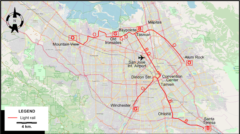
I created the above map by overlaying OpenStreetMap (OSM) maps with my own data. The underlying map data is © OpenStreetMap contributors, licensed under the Open Database License (ODbL).
Please note that the OSM map used as a template for this map corresponds to the situation at the time the map was downloaded and may show features that did not exist at the time the GS Tram Site is supposed to show. In particular, it may show bridges and highways that were built later.
LIGHT RAIL ROUTES
Operator:Valley Transportation Authority (VTA)
| B | Blue Line | Baypointe - Tasman – San Jose Int. Airport - Convention Center – Tamien – Ohlone – Santa Teresa |
| G | Green Line | Old Ironsides - Tasman – San Jose Int. Airport - Convention Center – Diridon Station – Winchester |
| O | Orange Line | Mountain View – Old Ironsides - Tasman – Baypointe - Alum Rock |
Note: The one-letter abbreviations (B, G and O) are for convenience only, they are not used by the operator.
CHARACTERISTICS OF THE SYSTEM
NETWORK LENGTH
- Light rail lines: 64.5 km.
HISTORY
- Streetcars: 1890 - 1938
- Light rail: 10 Dec. 1987 - today.
GAUGE
- Light rail: 1435 mm.
SOURCES
- Gillham, J.C. & Ballinger, M.V. "Light Rail years ahead", Modern Tramway & Light Rail Transit, May 1988 (51:605), p.166-177.
- Simons, V. "The low-down on San Jose", Tramways & Urban Transit, Sept. 2016 (79:945), p.340-343.
- Wolinsky, J. "San Jose report", Modern Tramway & Light Rail Transit, Mar. 1987 (50:591), p.84-86.
WIKIS
WEB SITES
- Making transit work in San Jose (In: The Transport Politic (by Yonah Freemark )
- San Jose: Light Rail transit overview
- Santa Clara Valley Transportation Authority (VTA)
Copyright Gabor Sandi 1998-2026
Disclaimer: Everything on this site was written and/or prepared at the author's discretion. The author has tried to be accurate where facts are presented, but this does not mean that these facts are necessarily accurate. People needing more reliable information should refer to appropriate sources presented, on the Internet or elsewhere, by authoritative professional or academic bodies.
To get in touch with the webmaster, send an e-mail to g_sandi at hotmail.com.
Flags on this site are from the FOTW Flags Of The World website.