 |
 |
 |

FIRST INSET: DOWNTOWN CHICAGO

SECOND INSET: INTERURBAN NETWORK AROUND CHICAGO

I created the above maps by overlaying OpenStreetMap (OSM) maps with my own data. The underlying map data is © OpenStreetMap contributors, licensed under the Open Database License (ODbL).
Please note that the OSM maps used as a template for these maps corresponds to the situation at the time the map was downloaded and may show features that did not exist at the time the GS Tram Site is supposed to show. In particular, it may show bridges and highways that were built later.
ABBREVIATIONS ON THE MAPS
| BM | Belmont Station | MF | Marshfield Station |
ROUTES
STREETCAR ROUTES
Operator: Chicago Transit Authority (CTA)
| 4 | Cottage Grove | W Randolph St. & N Wabash Av. - Wabash Av. - Indiana Av. - Cottage Grove Av. - 115th St. |
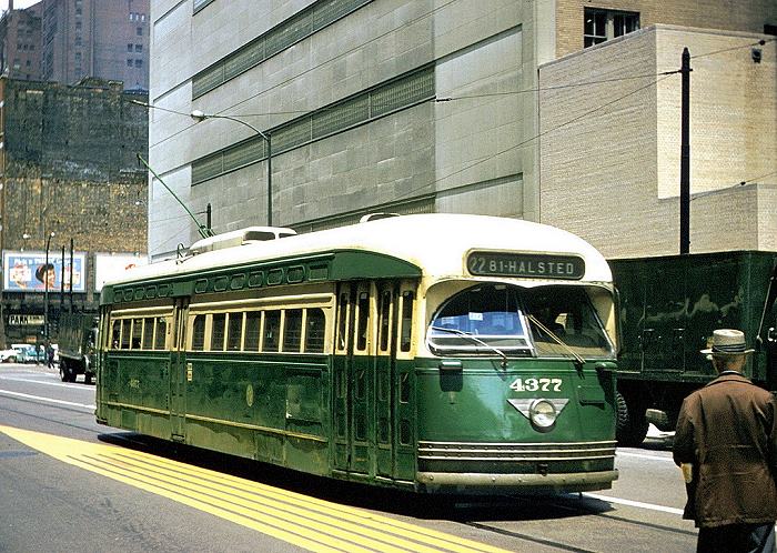
| 8 | Halsted | Grace St. & Broadway - Halsted St. - W 79th St. |
| 16 | Lake | Austin Bvd. (City limits) - Lake St. - State St. - Downtown (Van Buren St.)1 |
| 21 | Cermak | Kenton Av. (City limits) - Cermak Rd. - Burnham Park |
| 22 | Clark | Howard St. (City limits) - Clark St. - S Wentworth Av. - Vincennes Av. - W 81st St. & S Halsted St. |
| 36 | Broadway | N Clark St. - Devon Av. - Broadway - N Clark St. - N State St. - S State St. - Indiana Av. - S Michigan Av. - 119th St. - S Morgan St. |
| 42 | Halsted Downtown | Lake St. - [State St.] [back: Polk St. - Dearborn St.] - State St. - Archer Av. - S Halsted St. - W 79th St. |
| 49 | Western | Berwyn Av. - Western Av. - W 79th St. |
| 52 | Kedzie - California | Roscoe St. - N California Av. - W Chicago Av. - Kedzie Av. - Marquette Park (W 67th St.) |
1 Putting the downtown terminus of line 16 (State) at the intersection of Van Buren St. and State St. is pure guess - but it must have been somewhere!
Service discontinuation dates between 26 Feb. 1951 and 30 May 1954 (corresponding route numbers in brackets):
- 1951 March 11: Lincoln Av.; connection between State & Wabash streets, between Lake & Randolph (3)
- 1951 Apr. 1: Grand Av. (65); Lawrence Av. (81)
- 1951 Apr. 15: 35th St. (35); 47th St. (47)
- 1951 May 13: Damen Av. (50)
- 1951 May 24: Armitage Av. (56X,73)
- 1951 May 27: 87th St. (87A); E 95th St. - E 93rd St. - E 92nd St. - Buffalo Av. (95E)
- 1951 June 29: Stony Island Av. (28)
- 1951 July 27: Racine Av. & Wallace St. (44)
- 1951 Aug. 12: Van Buren St. (6); Roosevelt Rd. (12)
- 1951 Sept. 16: Pulaski Av. (53); Ogden Av. - Randolph St. / Washington St. (58); 79th St. (79)
- 1951 Nov. 25: Cicero Av. (54)
- 1952 May 11: Milwaukee Av. (56); 26th St. - Blue Island Av. - Harrison St. - S Clinton St. - W Monroe St. / W Adams St. (60); Chicago Av. (exc. for between California Av. and Kedzie Av.) (66)
- 1953 Apr. 11: Roosevelt Shuttle (east of Michigan Av.) (12)
- 1953 May 24: Indiana Av. (38); 63rd St. (63); W 71st St. - W 69th St. - E 67th St. (67)
- 1953 Aug. 9: Root and 53rd Streets (43)
- 1953 Dec. 11: Madison St. (20)
- 1954 Feb. 12: Ashland Av. (9); Archer Av. (between Halsted & Ashland) (45)
- 1954 Feb. 19: Fifth Av. (20X)
- 1954 May 30: Halsted St. (8; S of Archer Av., also 42); Lake St. (16), Cermak Rd. (21); Archer Av. & S Dearborn St. (42); N California Av. - W Chicago Av. (small section) - Kedzie Av. (52)
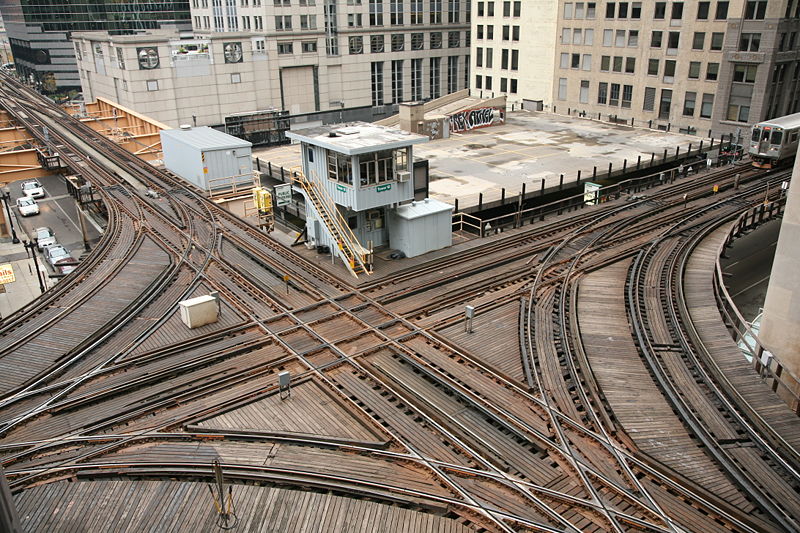
RAPID TRANSIT ROUTES (ELEVATED RAILROADS AND SUBWAYS)
Operator: Chicago Transit Authority (CTA)
Note: The one and two-character codes used to identify routes below and in the maps are for convenience only, and were not used by the operating company.
| 1 | State Street Subway | Roosevelt Rd. - State St. - Division St. - Clybourn Av. - North Av. |
| 2 | Milwaukee-Dearborn Subway | La Salle Stn - Dearborn St. - Lake St. - Milwaukee Av. - Damen Stn. - Logan Square |
| DP | Douglas Park Line | Loop - (Lake Street Line) - Marshfield - Douglas Park - 54th Av. |
| EH | Englewood - Howard | Englewood - Pershing Rd. Station - Roosevelt Rd. - State Street Subway - Belmont - Howard St. |
| EL | Evanston - Loop | Linden (Evanston) - Howard St. - Belmont - Pershing Rd. Station - Loop [Rush-hour express service] |
| EW | Evanston-Wilmette Branch | Howard Street - Linden (Evanston) [Shuttle] |
| GP | Garfield Park Line | Loop - Marshfield - Garfield Park - Columbus Park (Austin) - Forest Park (Des Plaines Av.) |
| JH | Jackson Park - Howard | Jackson Park - Pershing Rd. Station - Roosevelt Rd. - State Street Subway - Belmont - Howard Street |
| KI | Kenwood - Indiana Av. | Kenwood - Indiana Av. [Shuttle] |
| L | Lake Street Line | Loop - Lake Street - Forest Park |
| RL | Ravenswood - Loop | Kimball Stn. - Belmont - Loop |
| SI | Stock Yards - Indiana Av. | Stock Yards - Indiana Av. [Shuttle] |
INTERURBAN ROUTES
Operator: Chicago Aurora & Elgin Railroad (CA&E)
| AE&C Line | Forest Park (Des Plaines Av.) - Bellwood - Wheaton - (Elgin) / (Batavia Jnctn. - Batavia) / (Batavia Jnctn. - Aurora) |
Operator: Chicago North Shore and Milwaukee Railway
| Skokie Valley - Mundelein Route | Chicago - Dempster (Skokie) - Lake Bluff - Libertyville - Mundelein | |
| Shore Line Route | Chicago - Linden (Evanston) - Lake Bluff - North Chicago - Waukegan | |
| Skokie Valley - Milwaukee Route | Chicago - Dempster (Skokie) - Lake Bluff - North Chicago - Kenosha - Racine - Milwaukee |
Operator: Chicago South Shore and South Bend Railroad
| South Shore Line | Randolph Street Terminal - Roosevelt Rd. Station - 63rd St. Station - Kensington 115th St. - East Chicago - Gary - South Bend |
ELECTRIC COMMUTER ROUTES (IC ELECTRIC)
Operator: Illinois Central Railroad
| Blue Island Branch | Randolph Street Terminal - Roosevelt Rd. Station - 63rd St. Station - Kensington 115th St. - Blue Island | |
| Main Line | Randolph Street Terminal - Roosevelt Rd. Station - 63rd St. Station - Kensington 115th St. - Riverdale - Harvey - Richton Park | |
| South Chicago Branch | Randolph Street Terminal - Roosevelt Rd. Station - 63rd St. Station - South Chicago (E 93rd Street) |
CHARACTERISTICS OF THE SYSTEM
NETWORK LENGTH
- Streetcar lines: ? km.
- Subway: ? km.
- Elevated lines: ? km.
- Interurban lines:
- Chicago Aurora & Elgin Railroad (CA&E): ? km.
- Chicago North Shore and Milwaukee Railway: 165 km.
- Chicago South Shore & South Bend Railroad: 141 km.
- Electric commuter line (Illinois Central): 46 km.
HISTORY
- Horse-drawn streetcars: 25 Apr. 1859 - 1906.
- Compressed-air streetcars: 1890 - 1986.
- Battery streetcars: 1896 - 1 July 1901.
- Cable cars: 28 Jan. 1882 - 23 July 1906.
- Electric streetcars: 2 Oct. 1890 - 21 June 1958.
- Interurbans:
- Chicago, Aurora & Elgin line: 25 Aug. 1902 - 3 July 1957.
- North Shore Line: 1895 - 21 Jan. 1963.
- South Shore Line: 1903 - today.
- Chicago & West Towns Railways: (horse-drawn) Feb. 1889 - 1891; (electric) 1891 - 10 Apr. 1948.
- Subway: 17 Oct. 1943 - today.
- Elevated (or "L") lines: 6 June 1892 - today.
- Commuter line (formerly, Illinois Central): 21 July 1856 - today (originally, steam; electrified since 1926).
GAUGE
- All systems: 1435 mm.
TRAM PRESERVATION
The Illinois Rail Museum, in Rockford, IL, about 100 km. NW from Chicago, has about 10 preserved Chicago streetcars, and a large number of preserved interurban and rapid transit vehicles that used to run in the Chicago area. Many of them run regularly on the museum tracks.
SOURCES
- Buckley, J.J. Chicago & West Towns Railways. Chicago: Central Electric Railfans Association, 2006.
- Lind, A.R. Chicago Surface Lines - An illustrated history (3rd. ed.). Park Forest (Ill.): Transport History Press, 1979.
- Map of Chicago Rapid Transit Lines. Chicago: Chicago Rapid Transit Company, 1946.
- Johnson, J.D. A century of Chicago streetcars. Wheaton (Ill.): The Traction Orange Co., 1964.
- Simons, V. "Chicago: Modernisation and renewal" Tramways & Urban Transit, Jan. 2014 (77: 913), p.17-21.
- Taplin, M.R. Tramways of North America, including rapid transit [Tramway Handbooks No.4] Hassocks (West Sussex, England): Light Rail Transit Association, 1981.
WIKIS
- Chicago Aurora & Elgin Railroad (CA&E)
- Chicago 'L'
- Chicago North Shore and Milwaukee Railroad
- Chicago Rapid Transit Company
- Chicago Surface Lines
- Chicago Transit Authority
- Illinois Railway Museum
- Metra Electric District
- South Shore Line (NICTD)
- Transportation in Chicago
WEB SITES
- Cable Car Lines in Chicago
- Chicago (on UrbanRail.Net)
- Chicago Transit Authority (CTA)
- GreatThirdRail.org: The Chicago Aurora & Elgin Internet Resource
- Illinois Railway Museum
- South Shore Line Passenger Service
- www.Chicago "L".org
Also, thanks to Emmert Clevenstine of Ferney-Voltaire, France, for relevant documents he has given me over the years, as well as to Russell Powers from Denver CO and Peter Zondag from the Netherlands for their kind suggestions sent over the Internet.
Copyright Gabor Sandi 1998-2026
Disclaimer: Everything on this site was written and/or prepared at the author's discretion. The author has tried to be accurate where facts are presented, but this does not mean that these facts are necessarily accurate. People needing more reliable information should refer to appropriate sources presented, on the Internet or elsewhere, by authoritative professional or academic bodies.
To get in touch with the webmaster, send an e-mail to g_sandi at hotmail.com.
Flags on this site are from the FOTW Flags Of The World website.