VIDEO
 |
| Above: YouTubeCA video -Take a trip through history at the Phoenix Trolley Museum | Rediscover Arizona - Length: 2:54 mins. |
PHOTO

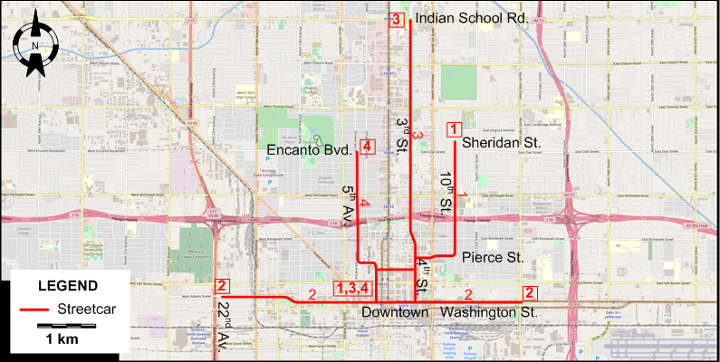
I created the above map by overlaying OpenStreetMap (OSM) maps with my own data. The underlying map data is © OpenStreetMap contributors, licensed under the Open Database License (ODbL).
Please note that the OSM map used as a template for this map corresponds to the situation at the time the map was downloaded and may show features that did not exist at the time the GS Tram Site is supposed to show. In particular, it may show bridges and highways that were built later.
DISCONTINUATION DATES OF TRAM TRACKS BETWEEN 26 APR. 1946 AND 16 FEB. 1948 (affected route numbers in parantheses).
- 1946 Apr. 26: Pierce St. - 10th St. (Brill line, No.1)
- 1947 Apr. 16: 2nd. Av. - 5th Av. (Kenilworth Line, No.3)
- 1947 Aug. 15: 4th St. - 3rd St. (Indian School Line, No.4
- 1948 Feb. 16: Washington St. (Washington St. Line, No.2)
STREETCAR ROUTES
Operator: Phoenix Street Railway
| 1 | Brill | Downtown - Pierce St. - 10th St. - Sheridan St. |
| 2 | Washington St. | 22nd Av. - Washington St. - 16th St. |
| 3 | Kenilworth | Downtown - 5th Av. - Encanto Blvd. |
| 4 | Indian School | Downtown - 4th St. - 3rd St. - Indian School Rd. |
CHARACTERISTICS OF THE SYSTEM
NETWORK LENGTH
- Streetcar network: ?
HISTORY
- Horse-drawn steetcars: 1887 - June 1895.
- Streetcars (1st generation): 28 Sept. 1893 - 16 Feb. 1948.
- Streetcars (2nd generation, Tempe): 20 May 2022 - today.
- Light rail: 27 Dec. 2008 - today.
- Airport sky train: 8 Apr. 2013 - today.
GAUGE
- Modern streetcar & Light rail: 1435 mm.
- Airport sky train: Automated guideway system
TRAM PRESERVATION
The Phoenix Trolley Museum has a collection of old streetcars.
SOURCES
- Fleming, L.J. Ride a mile and smile the while: A history of the Phoenix Street Railway, 1887-1948. Phoenix: Swaine Publications, 1977.
- "Funding gap hits Phoenix extensions", Tramways & Urban Transit, Sept. 2009 (72: 861), p.354.
- Grahl, A. "Phoenix: South Central extension", Tramways & Urban Transit, Aug. 2025 (88: 1052), p.297-298.
- Simons, V. "Phoenix: A city rescued by light rail", Tramways & Urban Transit, March 2009 (72:855), p.94-97.
- Simons, V. "Phoenix light rail takes flight again", Tramways & Urban Transit, Apr. 2017 (80:952), p.138-142.
- Simons, V. "Phoenix spreads its wings", Tramways & Urban Transit, Nov. 2014 (77:923), p.94-97.
- "Phoenix Street Railway 1887-1948", Western Railroader, 1961 (24:254).
- Ziech, M. & Tierney, S. "Phoenix: The rise of the streetcar", Tramways & Urban Transit, Feb. 2024 (87:1034), p.48-51.
WIKIS
- Phoenix Street Railway
- PHX Sky Train
- Tempe Streetcar
- Valley Metro (Phoenix)
- Valley Metro Rail (Phoenix)
WEB SITES
- All aboard Arizona (formerly: Arizona Rail Passenger Association)
- A Brief History Of Public Transportation in Metro Phoenix
- Friends of Transit
- Phoenix 101: streetcars (from: Rogue Columnist, 28 Feb. 2017)
- PHX Sky Train
- Valley Metro
Special thanks to Russell Powers of Denver, Colorado for his kind help sending me information on the Phoenix streetcar network.
Copyright Gabor Sandi 1998-2026
Disclaimer: Everything on this site was written and/or prepared at the author's discretion. The author has tried to be accurate where facts are presented, but this does not mean that these facts are necessarily accurate. People needing more reliable information should refer to appropriate sources presented, on the Internet or elsewhere, by authoritative professional or academic bodies.
To get in touch with the webmaster, send an e-mail to g_sandi at hotmail.com.
Flags on this site are from the FOTW Flags Of The World website.