VIDEOS
 |
 |
| Above: YouTubeCA video - New Orleans St. Charles Streetcar Line - Length: 12:13 mins. | Above: YouTubeCA video - New Orleans Streetcar (NORTA): St. Charles Line (Line 12) -- FULL RIDE! - Length: 47:13 mins. |
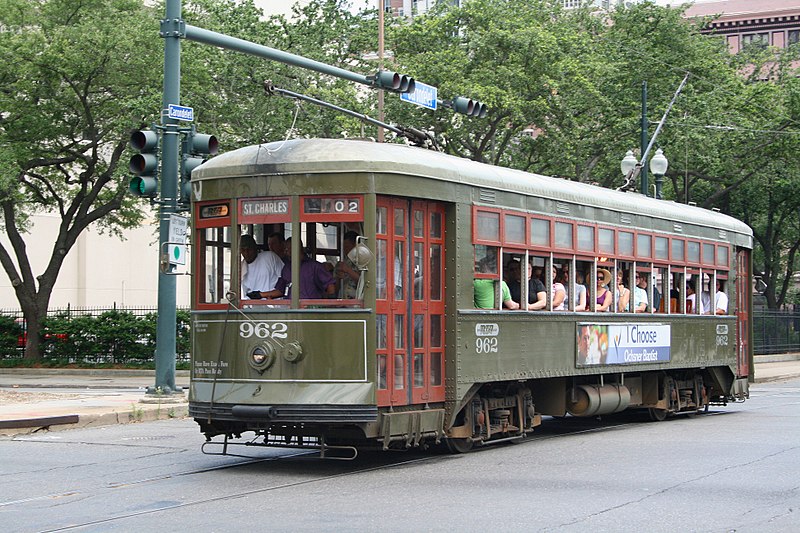
PHOTO
MAPS
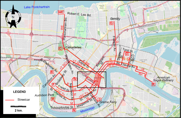
INSET: CENTRAL NEW ORLEANS

I created the above maps by overlaying OpenStreetMap (OSM) maps with my own data. The underlying map data is © OpenStreetMap contributors, licensed under the Open Database License (ODbL).
Please note that the OSM maps used as a template for these maps corresponds to the situation at the time the map was downloaded and may show features that did not exist at the time the GS Tram Site is supposed to show. In particular, it may show bridges and highways that were built later.
DISCONTINUATION DATES OF STREETCAR LINES BETWEEN 1945 AND 1964
- 1946 Dec. 1: Freret
- 1947 May 19: Jackson
- 1948 Feb. 11: Magazine
- 1948 May 29: Desire
- 1948 July 17: Gentilly
- 1949 Jan. 1: St. Claude
- 1950 Jan. 15: West End
- 1951 Jan. 8: Tulane
- 1953 Jan. 5: S Claiborne
- 1953 Feb. 18: Napoleon
- 1964 May 29: Canal / West End
STREETCAR ROUTES
Operator: New Orleans Public Service Incorporated (NOPSI)
| B | S Claiborne | Canal St. - [St. Charles Av. - Howard Av. - S Claiborne Av.] [back: Erato St. - Carondelet St.] - S Claiborne Av. - Carrollton Av. |
| C | Canal | Algiers Ferry - Canal St. - Cemeteries |
| D | Desire | Canal St. - [Dauphine St. - Desire St.] [back: France St. - Royal St.] - Tonti St. |
| F | Freret | Canal St. - [St. Charles Av. - Julia St. - Freret St.] [back: Erato St. - Carondelet St.] - Freret St. - Broadway St. |
| G | Gentilly | Canal St. - Dauphine St. [back: Royal St.] - Franklin Av. - Gentilly |
| J | Jackson | Canal St. - [Baronne St. - Howard Av.] [back: S Rampart St.] - Dryades St. (Oretha Castle Haley Boulevard) - Jackson Av. - Gretna Ferry |
| M | Magazine | Canal St. - Magazine St. [back: Camp St.] - Magazine St. - Audobon Park |
| N | Napoleon | Tchoupitoulas St. - Napoleon Av. - Washington Av. |
| R | St. Claude | Canal St. - Rampart St. - St. Claude Av. - American Sugar Refinery |
| SC | St. Charles | Dauphine St. - Baronne St. - Howard Av. - St. Charles Av. - Carrollton Av. - Tulane Av. - Canal St. - Dauphine St. [Circular route, clockwise] |
| T | Tulane Belt | Algiers Ferry - Canal St. - S Rampart St. - Tulane Av. - Carrollton Av. - St. Charles Av. - Howard Av. - Carondelet St. - Canal St. - Algiers Ferry [Loop route, counterclockwise] |
| WE | West End | Algiers Ferry - Canal St. - Pontchartrain Bd. - Robert E. Lee Bd. |
NB: The one and two-letter route designations used above are for convenience only, and were not used by the operator.
CHARACTERISTICS OF THE SYSTEM
NETWORK LENGTH
- Streetcars: ? km.
HISTORY
- Horse-drawn streetcars: 23 Apr. 1831 (oldest continuous streetcar service in the world) - 1895 (?).
- Steam-operated streetcars: 27 Sept. 1832 - 1874 (?).
- Electric streetcars: 1 Feb. 1893 - today.
GAUGE
- Streetcars: Origins - 1929: 1,435 mm.; 1929 - today: 1,588 mm.
SOURCES
- Hennick, L.C. & Charlton, E.H. The streetcars of New Orleans. Gretna (LA): Jackson Square Press, 1975.
- Lietwiler, C.J. "New Orleans: Streetcars return to Canal Street", Tramways & Urban Transit, Dec. 2004 (67: 803), p.452-456.
- Rice, W.E. "New Orleans: Where Perley Thomas streetcars still rule", Light Rail & Modern Tramway, Nov. 1997 (60: 719), p.422-425.
- Simons, V. "New Orleans desires streetcar expansion", Tramways & Urban Transit, May 2018 (81: 965), p.173-175.
- Simons, V. "New Orleans: Five years on from Katrina", Tramways & Urban Transit, June 2010 (73: 870), p.214-217.
- Simons, V. "New Orleans is finally on the move - and on the up", Tramways & Urban Transit, May 2014 (77: 917), p.198-200.
WIKIS
WEB SITES
- New Orleans streetcars
- Railway preservation - U.S. Streetcar Systems- Louisiana
- RTA - Regional Transit Authority
Also, many thanks to Mr Russell Powers of Lone Tree, CO, USA, for kindly sending me copious amounts of information and documents concerning the history of the New Orleans streetcar system.
Copyright Gabor Sandi 1998-2026
Disclaimer: Everything on this site was written and/or prepared at the author's discretion. The author has tried to be accurate where facts are presented, but this does not mean that these facts are necessarily accurate. People needing more reliable information should refer to appropriate sources presented, on the Internet or elsewhere, by authoritative professional or academic bodies.
To get in touch with the webmaster, send an e-mail to g_sandi at hotmail.com.
Flags on this site are from the FOTW Flags Of The World website.