MAP
I created the above map by overlaying OpenStreetMap (OSM) maps with my own data. The underlying map data is © OpenStreetMap contributors, licensed under the Open Database License (ODbL).
Please note that the OSM map used as a template for this map corresponds to the situation at the time the map was downloaded and may show features that did not exist at the time the GS Tram Site is supposed to show. In particular, it may show bridges and highways that were built later.
STREETCAR ROUTES
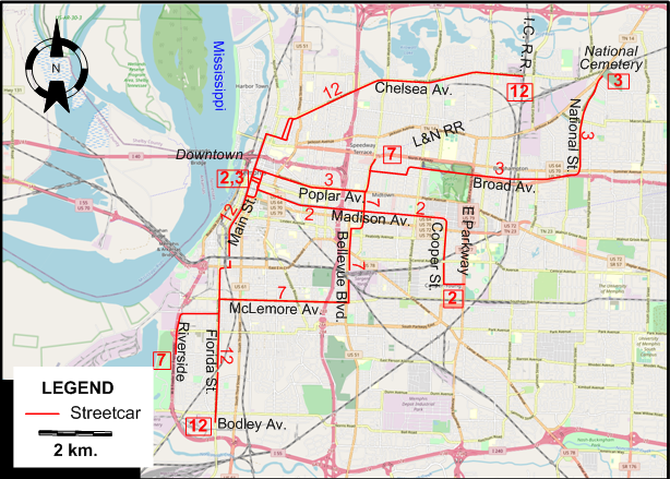
Operator: Memphis Street Railway Co.
| 2 | Fairgrounds - Park | Downtown - Madison Av. - Cooper St. - E Parkway |
| 3 | National | Downtown - Poplar Av. - Broad Av. - National St. - National Cemetery |
| 7 | Crosstown | Riverside - McLemore Av. - Bellevue Blvd. - L&N Railroad |
| 12 | Chelsea - Florida | I.C.R.R. - Chelsea Av. - Main St. - Florida St. - Bodley Av. |
CHARACTERISTICS OF THE SYSTEM
NETWORK LENGTH
- Streetcar lines: ? km.
HISTORY
- Horse-drawn streetcars: 2 June 1866 – 1895.
- Steam-dummy streetcars: 1886 - 1895.
- Electric streetcars (first generation): 6 Oct. 1890 – 15 June 1947.
- Interurbans (Memphis and Lakeview Traction): 1910 – 30 Apr. 1928.
- Modern (heritage) streetcars: 29 Apr. 1993 - 18 Aug. 2024.
- Memphis Suspension Railway (Monorail): 3 July 1982 - today.
GAUGE
- All rail systems: 1435 mm.
SOURCES
- Simons, V. "Memphis: City with a real role for streetcars", Tramways & Urban Transit, Aug. 2010 (73: 872), p.303-305.
- Simons, V. "Memphis streetcars are back on track", Tramways & Urban Transit, July 2018 (81: 967), p.252-253.
WIKIS
WEB SITES
- Memphis Area Transit Authority (MATA)
- Memphis Street Railway Street Cars
- Mud Island River Park Monorail
Also, many thanks to Mr Russell Powers of Lone Tree, CO, USA, for kindly sending me information and documents concerning the history of the Memphis streetcar system.
Copyright Gabor Sandi 1998-2026
Disclaimer: Everything on this site was written and/or prepared at the author's discretion. The author has tried to be accurate where facts are presented, but this does not mean that these facts are necessarily accurate. People needing more reliable information should refer to appropriate sources presented, on the Internet or elsewhere, by authoritative professional or academic bodies.
To get in touch with the webmaster, send an e-mail to g_sandi at hotmail.com.
Flags on this site are from the FOTW Flags Of The World website.