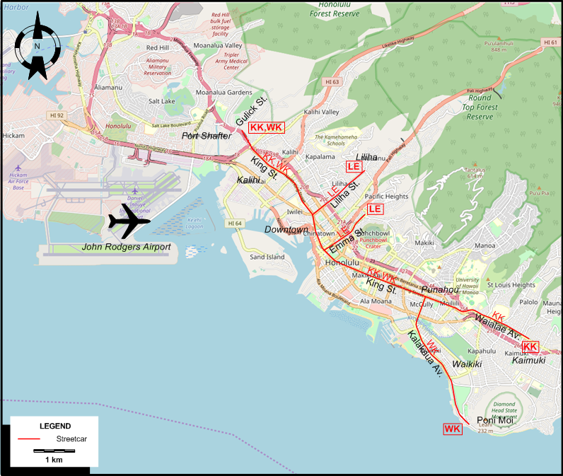
ABBREVIATIONS ON THE MAP
| FS | Fort Street | HS | Hotel Street |
I created the above map by overlaying OpenStreetMap (OSM) maps with my own data. The underlying map data is © OpenStreetMap contributors, licensed under the Open Database License (ODbL).
Please note that the OSM map used as a template for this map corresponds to the situation at the time the map was downloaded and may show features that did not exist at the time the GS Tram Site is supposed to show. In particular, it may show bridges and highways that were built later.
STREETCAR ROUTES
Operator: Honolulu Rapid Transit Co.
| KK | Kaimuki - Kalihi | Kaimuki - Waialae Av. - King St. - Kalihi (Gulick St.) |
| LE | Liliha - Emma Street | Liliha - Liliha St. - Downtown - Emma St. |
| WK | Waikiki - Kalihi | Waikiki (Poni Moi) - Kalakaua Av. - King St. - Kalihi (Gulick St.) |
CHARACTERISTICS OF THE SYSTEM
NETWORK LENGTH
- Streetcars: 19 km.
HISTORY
- Animal-drawn (mule powered) streetcars: 1888 - 1900.
- Electric streetcars (1st generation): 1900 (?) - 30 June 1941.
GAUGE
- ?
SOURCES
- Honolulu Rapid Transit Co. A time schedule and list of routes. 1936.
- Melvin, R.S. & ramsey, R. Hawaiian tramways. San Marino (CA): Golden West Books, 1976.
WIKIS
WEB SITES
Special thanks to Russell Powers from Denver CO for information on the history of the Honolulu streetcar system.
Copyright Gabor Sandi 1998-2026
Disclaimer: Everything on this site was written and/or prepared at the author's discretion. The author has tried to be accurate where facts are presented, but this does not mean that these facts are necessarily accurate. People needing more reliable information should refer to appropriate sources presented, on the Internet or elsewhere, by authoritative professional or academic bodies.
To get in touch with the webmaster, send an e-mail to g_sandi at hotmail.com.
Flags on this site are from the FOTW Flags Of The World website.