VIDEOS
 |
 |
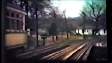
| Above: YouTubeCA video - Part 1/7 Kansas City Streetcars - Length: 9:39 mins. | Above: YouTubeCA video -Part 7/7 Kansas City Streetcars - Length: 13:52 mins. |
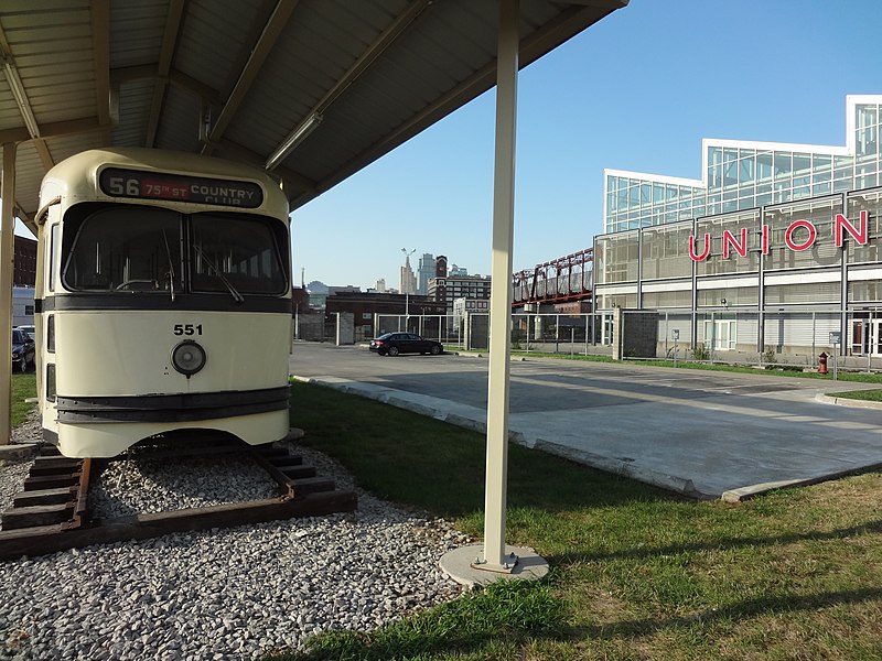
PHOTO
 |
MAPS
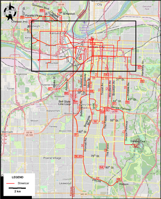
CENTRAL KANSAS CITY

ABBREVIATIONS ON THE MAPS
| MG | McGee St. | Wd | Wyandotte St. |
| RhR | Rockhill Rd. |
I created the above maps by overlaying OpenStreetMap (OSM) maps with my own data. The underlying map data is © OpenStreetMap contributors, licensed under the Open Database License (ODbL).
Please note that the OSM maps used as a template for these maps corresponds to the situation at the time the map was downloaded and may show features that did not exist at the time the GS Tram Site is supposed to show. In particular, it may show bridges and highways that were built later.
ROUTES
Operator: Kansas City Public Service Co. (KCPS)
STREETCAR ROUTES
| 50 | Troost Ave. | Walnut St. - E 10th St. [back: E 8th St.] - Troost Av. - 55th St. |
| 51 | Brooklyn - Sunset Hill | 44th St. - Brooklyn Av. - E 10th St. - Grand Blvd. - Broadway - Belleview Av. - 60th St. |
| 52 | Woodland | E 8th St. - Grand Blvd. - E 19th St. [back: E 18th St.] - Charlotte St. - Holmes St. - 31st St. - Woodland Av. - Swope Parkway [now: Martin Luther King Jr. Blvd.] |
| 53 | Swope Park | Independence Av. - Walnut St. - E 18th St. [back: 19th St.] - Main St. - Rockhill Rd. - Troost Av. - Swope Parkway [now: Martin Luther King Jr. Blvd.] - Swope Parkway - Swope Park |
| 54 | Vine - Observation Park | 31st St. - Vine St. - E 18th St. [back: 19th St.] - Walnut St. - 5th St. - Broadway - Observation Park |
| 55 | 31st St. | 9th St. - Main St. - E 24th St. - Grand Blvd. - 31st St. - Hardesty Av. |
| 56 | Country Club | 56st St. - Main St. - Brookside Blvd. - Wornall Rd. - 75th St. |
| 57 | Jackson-Roanoke | Hardesty Av. - E 24th St. - Jackson Av. - E 12th St. - W 12th St. - Broadway - SW Blvd. - Summit St. - 39th St. - Bell State Line Loop |
| 58 | 12th St.-Kansas Av. | Jackson Av. - E 12th St. - W 12th St. - Genessee St. [back: Wyoming St.] - Wyoming St. - Kansas Av. Bridge - Kansas Av. - 18th St. |
| 59 | Parallel-Indiana | 33rd St. - Parallel Pkwy - Chelsea Trafficway - 5th St. - Minnesota Av. - 6th St. - Central Av. Viaduct - W 12th St. - E 12th St. - Prospect Av. - E 18th St. - Indiana Av. - 43rd St. |
| 60 | Central Av. | 19th St - Central Av. - Central Av. Viaduct - 9th St. - 8th St. Tunnel - 8th St. - McGee St. |
| 61 | Minnesota-City Park | Main St. - 8th St. - 8th St. Tunnel - 9th St. - Central Av. - Central Av. Viaduct - James St. - Minnesota Av. - 18th St. - [Park Dr. - City Park] / [18th St. - Kansas Av.] |
| 62 | 18th Street | Jackson Av. - E 18th St. - E 18th St. [back: 19th St.- Olive St.] - SW Blvd. - W 24th St. - Kansas Av. Bridge - Berger Av. |
| 63 | North Prospect | E 15th St. [now: E Truman Rd.] - Prospect Av. - Independence Av. - Chestnut Av. - Lexington Av. |
| 64 | Marlborough | 48th & Troost - Troost Av. - Swope Parkway [now: Martin Luther King Jr. Blvd.] - The Paseo - 80th St. |
| 65 | Dodson | 75th St. - Wornall Rd. - PROW (Private Right of Way) - Dodson |
| 66 | 39th St. | Main St. - 39th St. - Adams St. |
| 67 | Rosedale | 5th St. - Wyandotte - W 12th St. - Broadway - W 14th St. - Summit St. - SW Blvd. - Boeke St. (Rosedale) |
| 68 | 7th & Haskell-Stock Yards | 7th & Haskell - 5th St. - Minnesota Av. - James St. - Genessee St. [back: Wyoming St.] - 16th St. |
| 69 | 10th St. | Quindaro Blvd. - 13th St. - Wood Av. - Walker Av. - 10th St. - Kansas Av. - Berger Av. |
| 70 | Kensington | 19th St - Central Av. - 29th St. - Chelsea Jnct. |
| 71 | 10th & Kansas Shuttle | Kansas Av. - 10th St. - Osage Av. - Pawnee Av. |
CHARACTERISTICS OF THE SYSTEM
NETWORK LENGTH
- Streetcar lines: ca. 310 km.
HISTORY
- Horse-powered streetcars: 1 Nov. 1870 - 27 Aug. 1898.
- Cable cars: 10 June 1885 - 13 Oct. 1913.
- Electric streetcars (1st generation): 9 Sept. 1889 - 23 June 1957.
- Interurbans: 1907- 24 July 1940.
- Electric streetcars (2nd generation): 6 May 2016 - today.
GAUGE
- Traditional systems: ?
- 1435 mm. (modern streetcrs)
SOURCES
- Conrad, E.A. "Kansas City streetcars: From hayburners to streamliners". Blue Springs (MI): HeartlandRails Publishing Company, 2011
- Retallick, H. "KC Streetcar: Looking to the future", Tramways & Urban Transit, Oct. 2016 (79: 946), p.377-380.
WIKIS
- Kansas City and Olathe Electric Railway
- Kansas City, Clay County and St. Joseph Railway
- Kansas City, Kaw Valley and Western Railway
- Kansas City, Leavenworth and Western Railway
- KC Streetcar
- Missouri and Kansas Interurban Railway
- Streetcars in Kansas City
WEB SITES
- RideKC Streetcar
Also, many thanks to Mr Russell Powers of Lone Tree, CO, USA, for kindly sending me information and documents concerning the history of the Kansas City streetcar and interurban systems.
Copyright Gabor Sandi 1998-2026
Disclaimer: Everything on this site was written and/or prepared at the author's discretion. The author has tried to be accurate where facts are presented, but this does not mean that these facts are necessarily accurate. People needing more reliable information should refer to appropriate sources presented, on the Internet or elsewhere, by authoritative professional or academic bodies.
To get in touch with the webmaster, send an e-mail to g_sandi at hotmail.com.
Flags on this site are from the FOTW Flags Of The World website.