VIDEOS
 |
 |
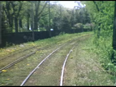
| Above: YouTubeCA video - A 1950s trip on the Como Harriet Line - Length: 16:54 mins. | Above: YouTubeCA video - 1950s Trip on the Inter-Campus Line - Length: 16:58 mins. |
PHOTOS
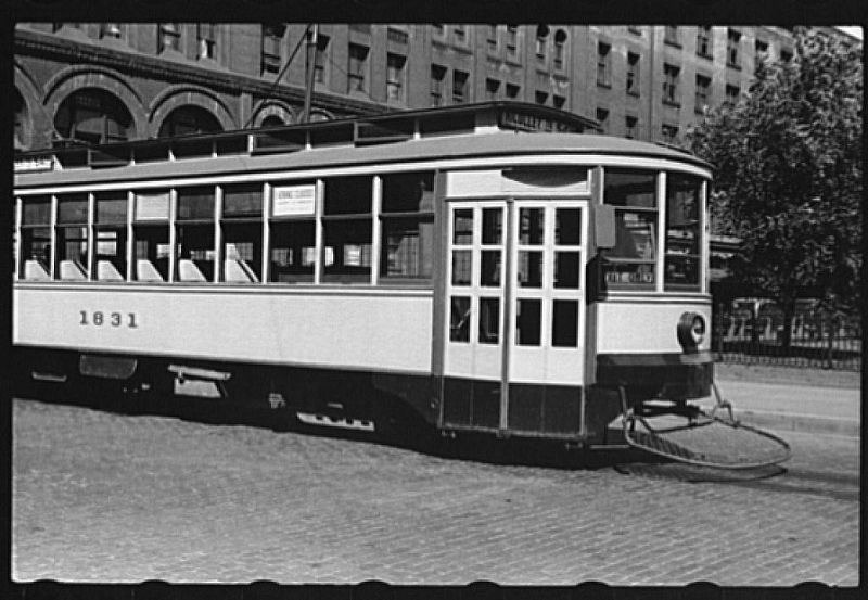 |
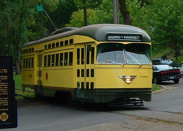 |
MAPS
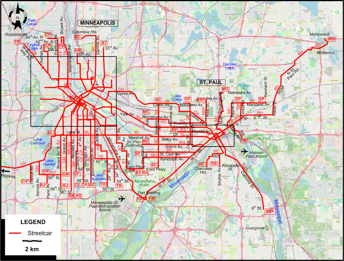
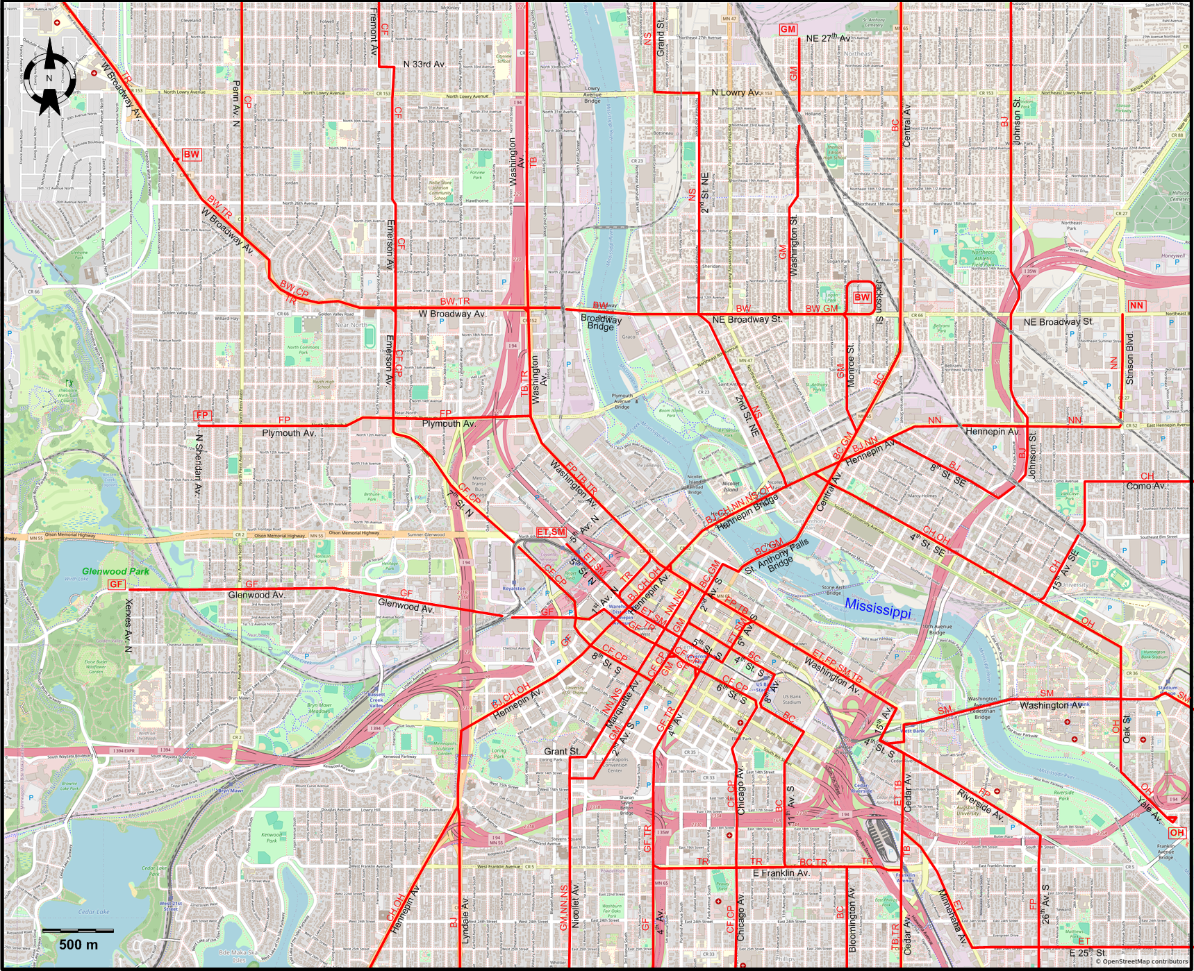
FIRST INSET: DOWNTOWN MINNEAPOLIS
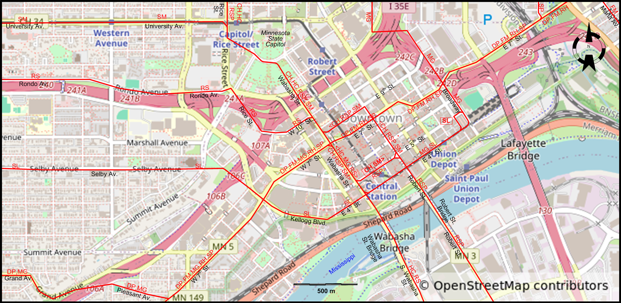
SECOND INSET: DOWNTOWN ST. PAUL
ABBREVIATIONS ON THE MAPS
| DA | N Dowling Av. (Minneapolis) | MSt | Mississippi St. (St. Paul) |
| DF | Dunning Field (St. Paul) | PA | Prior Av. (St. Paul) |
| ICB | Intercity Bridge | WS | Winifred St. (St. Paul) |
| MS | Mound St. (St. Paul) |
I created the above maps by overlaying OpenStreetMap (OSM) maps with my own data. The underlying map data is © OpenStreetMap contributors, licensed under the Open Database License (ODbL).
Please note that the OSM maps used as a template for these maps corresponds to the situation at the time the map was downloaded and may show features that did not exist at the time the GS Tram Site is supposed to show. In particular, it may show bridges and highways that were built later.
ROUTES
Operator: Twin City Rapid Transit Company (ancestor of Metro Transit)
STREETCAR ROUTES
INTERURBAN ROUTES CONNECTING MINNEAPOLIS AND ST. PAUL
| CH | Como – Harriet – Hopkins | E 5th St. (St. Paul) – [Robert St. - E 9th St.] [back: Wabasha St.] - Wabasha St. – Minnesota State Capitol – Rice St. - Como Av. (St. Paul) – Lake Como – Como Av. (Minneapolis) – 15th Av. SE - 4th St. SE – Hennepin Av. – Hennepin Bridge – Hennepin Av. – Lake Harriet – Hopkins / [CH*] France Av. |
| SL | Selby – Lake | Broadway (St. Paul) – E 4th St. – Kellogg Blvd. – Selby Av. – Fairview Av. - Marshall Av. – Lake St. – Hennepin Av. |
| SM | St. Paul – Minneapolis | EE 5th St. (St. Paul) – [Robert St. - E 9th St.] [back: Wabasha St.] – Wabasha St. – Minnesota State Capitol – University Av. – Washington Av. – Washington Av. Bridge - Washington Av. - 5th Av. S – 5th St. S – 5th Av. N |
MINNEAPOLIS ROUTES
| BC | Bloomington – Columbia Hts. | 54th St. (Lake Nokomis) – Bloomington Av. – E Franklin Av.- 11th Av. S - 6th St. S – 8th Av. [now Chicago Av.] - 4th St. S – 2nd Av. S – St. Anthony Falls Bridge – Central Av. – 39th Av. NE - Columbia Hts. (37th and 3rd) |
| BJ | Bryant – Johnson | [56th St. - Bryant Av.] / [BJ*] [54th St. - Penn Av.] – 50th St. – Bryant Av. S – Lake St. - Lyndale Av. – Hennepin Av. – Hennepin Bridge – Hennepin Av. – 8th St. SE – Johnson St. – 33rd Av. NE |
| BW | Broadway Crosstown | Upton Av. – W Broadway Av. – Broadway Bridge – NE Broadway St. - Jackson St. |
| CF | Chicago – Fremont | 54th St. – Chicago Av. – 6th St. – 2nd Av. S – 8th St. S – 7th St. N – Emerson Av. – N 33rd Av. - Fremont Av. – 44th Av. N (at Penn Av.) |
| CP | Chicago – Penn | 54th St. – Chicago Av. – 6th St. – 2nd Av. S – 8th St. S – 7th St. N – Emerson Av. – W Broadway Av. – Penn Av. N – N Dowling Av. - Thomas Av. - 42nd Av. N |
| ET | East 25th | Ford Plant (St. Paul) – Intercity Bridge [now Ford Parkway Bridge] - 46th Av. – E 38th St. - 42nd Av. – E 34th St. - 36th Av. – E 25th St. – Minnehaha Av. – Cedar Av. – Washington Av. – 5th Av. S – 5th St. S – 5th Av. N |
| FP | Ft. Snelling – Plymouth | Ft. Snelling – Minnehaha Falls – Minnehaha Av. – 26th Av. S - Riverside Av. – Washington Av. – Plymouth Av. - N Sheridan Av. |
| GF | Glenwood – 4th Av. | Glenwood Park (Xerxes Av. N) – Glenwood Av. – 1st Av. N – 6th St. – 4th Av. – 38th St. - Clinton Av. - 48th St. |
| GM | Grand – Monroe | 48th St. – Grand Av. – Lake St. - Nicollet Av. – 2nd Av. S – St. Anthony Falls Bridge – Central Av. – Monroe St. – Washington St. – 27th Av. |
| NN | Nicollet - NW Terminal | 58th St. – Nicollet Av. – Grant St. - Marquette Av. – Washington Av. - Hennepin Bridge – Hennepin Av. – Stinson Blvd. – NE Broadway St. |
| NS | Nicollet – 2nd St. NE | 58th St. – Nicollet Av. – Grant St. - Marquette Av. – Washington Av. - Hennepin Bridge – 2nd St. NE – N Lowry Av. - Grand St. (to 30th Av. NE) |
| OH | Oak – Harriet | Yale Av. – Oak St. – 4th St. SE – Hennepin Bridge – Hennepin Av. – Lake Harriet – Xerxes Av. - 50th St. - Penn Av. |
| TB | 34th Av. S – N. Bryant | 54th St. S – 34th Av. S – 42nd St. – 28th Av. S – Cedar Av. – Washington Av. – 44th Av. N - Bryant Av. - 42nd Av. |
| TR | 28th Av. S – Robbinsdale | 56th St. – 28th Av. S – 42nd St. – Cedar Av. – E Franklin Av. – 4th Av. – 5th St. S – 1st Av. N – Washington Av. – W Broadway Av. – Robbinsdale (42nd Av. N) |
ST. PAUL ROUTES
| DP | Dale – Phalen | Lake Como – Maryland Av. - Dale St. – Grand Av. - Pleasant Av. - W 7th St. – E 7th St. – Forest St. – Phalen Pk. |
| FM | Fort Snelling – Maria | Fort Snelling – W 7th St. – E 7th St. – Maria Av. – Mound St. - Indian Mounds Park |
| HC | Hamline – Cherokee Hts. | Prior Av. - Minnehaha Av. - Hamline Av. – Thomas Av. – Rice St. - Minnesota State Capitol – Wabasha St. – Wabasha St. Bridge – S. Wabasha St. – Winifred St. – Cherokee Hts. (Cherokee Av. & Annapolis St.) |
| MG | Mississippi – Grand | Nebraska Av. – Arkwright St. – Mississippi St. – Broadway – E 4th St. – Wabasha St. – W 7th St. – Grand Av. – St. Paul Seminary (Cleveland Av.) |
| RH | Randolph – Hazel Park – Mahtomedi | Ford Plant – Ford Pkwy. - Cleveland Av. - Randolph Av. – W 7th St. – E 7th St. – Hazel St. – N St. Paul Rd. – Wildwood – Mahtomedi |
| RS | Rondo – Stryker | Dunning Field (Chatsworth St.) – Rondo Av. – Rice St. - W 10th St. – Wabasha St. – Wabasha St. Bridge – S. Wabasha St. – Stryker Av. - Annapolis St. |
| RSP | Rice – S. St. Paul | Ivy Av. – Rice St. – Minnesota State Capitol – Wabasha St. – E 5th St. [back: Robert St. - E 9th St.] - Robert St. – Robert St. Bridge - Robert St. - Concord St. – Invergrove (6th St.) |
| SC | Snelling Crosstown | Como Av. – Snelling Av. – Ford Pkwy. |
| SP | St. Clair – Payne | Cleveland Av. – St. Clair Av. – W 7th St. – E 7th St. – Payne Av. – Maryland Av. – Kennard St. |
Tram routes in Minneapolis-St.Paul were identified by the main locations they passed by. The route identifiers used on the maps and below are strictly for convenience, and were never used by the Twin City Transit Co. itself.
CHARACTERISTICS OF THE SYSTEM
NETWORK LENGTH
- Streetcar lines: ca. 320 km.
HISTORY
- Streetcars:
- Horse-powered: St. Paul: July 1872 - 1892; Minneapolis: 2 Sept. 1875 - 1892.
- Electric: Minneapolis: 24 Dec. 1889 - 19 June 1954; St. Paul: 22 Feb. 1890 - 31 Oct. 1953.
- Light rail: 26 June 2004 - today.
GAUGE
- 1435 mm.
TRAM PRESERVATION
The Minnesota Streetcar Museum runs historic Minneapolis - St. Paul streetcars at two museum locations: adjacent to Lake Harriet in SW Minneapolis and at Excelsior, 15 miles (24 km) west of Minneapolis.
SOURCES
- Carter, J.M. "Minnesota: Streetcar named conspire", Tramways & Urban Transit, Nov. 2003 (66: 791), p.413-415.
- Diers, J.W. & Isaacs, A. Twin City Trolley: The streetcar era in Minneapolis and St. Paul. Minneapolis & London: University of Minnesota Press, 2007.
- Simons, V. "Minneapolis - St. Paul: Reconnecting the Twin Cities", Tramways & Urban Transit, Sept. 2014 (77: 921), p.362-367.
WIKIS
- METRO Blue Line
- Metro Transit (Minnesota)
- Minnesota Streetcar Museum
- Target Field (Metro Transit station)
- Twin City Rapid Transit Company
WEB SITES
- Metro Transit
- Minneapolis / St. Paul (on UrbanRail.Net)
- Minneapolis-St. Paul (Twin Cities) Public Transport
- Minnesota Streetcar Museum
Copyright Gabor Sandi 1998-2026
Disclaimer: Everything on this site was written and/or prepared at the author's discretion. The author has tried to be accurate where facts are presented, but this does not mean that these facts are necessarily accurate. People needing more reliable information should refer to appropriate sources presented, on the Internet or elsewhere, by authoritative professional or academic bodies.
To get in touch with the webmaster, send an e-mail to g_sandi at hotmail.com.
Flags on this site are from the FOTW Flags Of The World website.