MAP
I created the above map by overlaying OpenStreetMap (OSM) maps with my own data. The underlying map data is © OpenStreetMap contributors, licensed under the Open Database License (ODbL).
Please note that the OSM map used as a template for this map corresponds to the situation at the time the map was downloaded and may show features that did not exist at the time the GS Tram Site is supposed to show. In particular, it may show bridges and highways that were built later.
STREETCAR ROUTES
Operator: Capital Transportation Co.
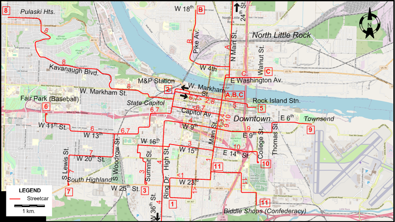
All routes with the exception of the shuttle line 11 originated downtown. The other numbered Little Rock routes were through-lined as follows: 1-8, 2-3, 4-5, 6-9, 7-10. The North Little Rock routes (A-C) originated downtown, but were not through-lined.
| 1 | South Main | Downtown - Main St. - W 23rd - Ring Dr. (Loop) |
| 2 | M&P Station | Downtown - W Markham St. - M&P Station |
| 3 | 15th Str. | Downtown - Main St. - W 15th St. - W 16th St. - Summit St. - W 25th St. [now W Roosevelt Rd.] |
| 4 | W 9th St. | Downtown - Main St. - W 9th St. - High St. [now Martin Luther King Drive] - W 36th St. |
| 5 | Rock Island Station | Downtown - E Markham St. [now Pres. Clinton Av.] - Rock Island Station |
| 6 | Fair Park | Downtown - Capitol Av. [back: W Markham St.] - State Capitol - W 13th St. - W 11th St. - Fair Park (Baseball) |
| 7 | S Highland | Downtown - Capitol Av. - [back: W Markham St.] - State Capitol - W 13th St. - S Woodrow St. - W 20th St. [now W Charles Bussey Av.] - S Lewis St. - S Highland |
| 8 | Pulaski Heights | Downtown - W Markham St. - Kavanaugh Blvd. - Pulaski Hts. |
| 9 | E 9th St. | Downtown - Main St. - E 9th St. - Thomas St. - E 6th St. - Townsend |
| 10 | E 14th St. | Downtown - Main St. - E 14th St. - College St. |
| 11 | Biddle Shops | Main St. - Biddle Shops (Confederacy [Now Springer Blvd.]) [Shuttle] |
| A | N Little Rock - Main | Downtown (Markham & Main) - Main St. Bridge - N Main St. - 24th St. (N Little Rock) |
| B | N Little Rock - Pike | Downtown (Markham & Main) - Main St. Bridge - N Main St. - W 4th St. (N Little Rock) - Pike Av. - W 18th St. (N Little Rock) |
| C | N Little Rock - Washington | Downtown (Markham & Main) - Main St. Bridge - N Main St. - E Washington Av. - Walnut St. |
Note: Numbered and lettered route designations are for convenience only; they were not used by the operator.
CHARACTERISTICS OF THE SYSTEM
NETWORK LENGTH
- Streetcar lines: ? km.
HISTORY
- Horse-drawn streetcars: 1876 - 1885
- Steam-operated streetcars ("dummies" with trailers): 3 July 1885 - 12 Jan. 1892
- Electric streetcars: 22 Nov. 1891 - 25 Dec. 1947
- Heritage streetcar lines: 1 Nov. 2004 - today
GAUGE
- 1435 mm.
SOURCES
- "Capitol Transportation Co." [Track and route map], Electric Railroaders' Association, 1944
- Wilkins, V. "Little Rock", Motor Coach Age, 1986.
WIKIS
WEB SITES
Also, many thanks to Mr Russell Powers of Lone Tree, CO, USA, for kindly sending me information and documents concerning the history of the Little Rock streetcar system. Some of this material is from Mr Van Wilkins.
Copyright Gabor Sandi 1998-2026
Disclaimer: Everything on this site was written and/or prepared at the author's discretion. The author has tried to be accurate where facts are presented, but this does not mean that these facts are necessarily accurate. People needing more reliable information should refer to appropriate sources presented, on the Internet or elsewhere, by authoritative professional or academic bodies.
To get in touch with the webmaster, send an e-mail to g_sandi at hotmail.com.
Flags on this site are from the FOTW Flags Of The World website.