 |
 |
 |
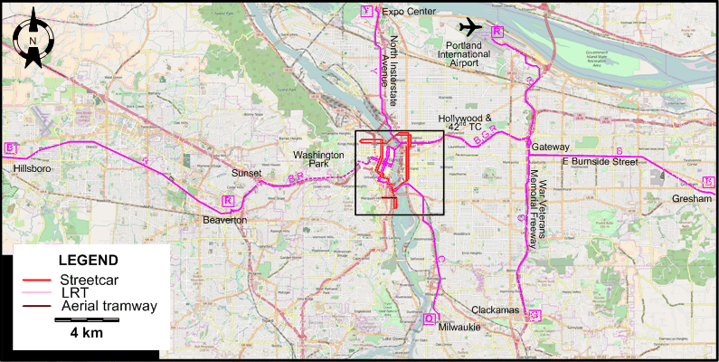
INSET: DOWNTOWN PORTLAND
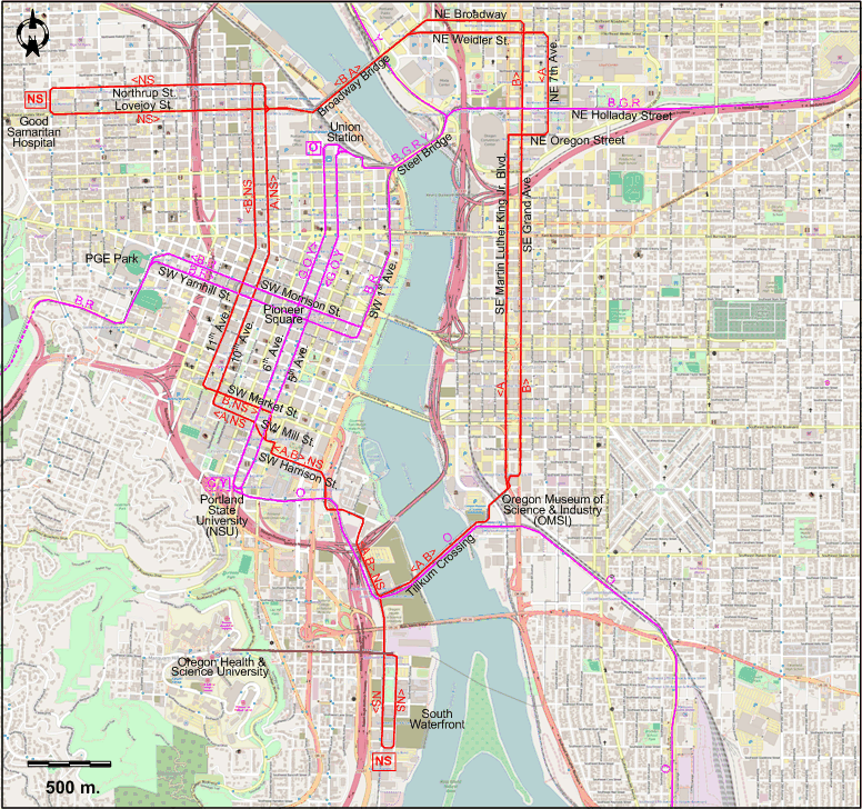
I created the above maps by overlaying OpenStreetMap (OSM) maps with my own data. The underlying map data is © OpenStreetMap contributors, licensed under the Open Database License (ODbL).
Please note that the OSM maps used as a template for these maps corresponds to the situation at the time the map was downloaded and may show features that did not exist at the time the GS Tram Site is supposed to show. In particular, it may show bridges and highways that were built later.
ROUTES
Operator: TriMet (Tri-County Metropolitan Transportation District of Oregon)
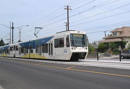
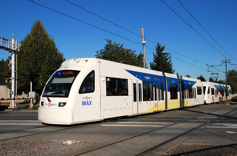
LIGHT RAIL ROUTES
| B | Blue Line | Hillsboro – Beaverton – Sunset – Washington Park – PGE Park – Library / SW 9th – Pioneer Square – SW 1st Ave. – Steel Bridge – NE Holladay Street – Hollywood & 42nd TC – Gateway – E Burnside Street – Gresham |
| G | Green Line | Portland State University (PSU) – 6th Ave. [back: 5th Ave.] (past Pioneer Square) – Union Station – Steel Bridge – NE Holladay Street – Hollywood & 42nd TC – Gateway – War Veterans Memorial Freeway – Clackamas |
| O | Orange Line | Union Station – 5th Ave. [back: 6th Ave.] (past Pioneer Square) - Portland State University (PSU) – Tilikum Crossing - Milwaukie |
| R | Red Line | Beaverton – Sunset – Washington Park – PGE Park – Library / SW 9th – Pioneer Square – SW 1st Ave. – Steel Bridge – NE Holladay Street – Hollywood & 42nd TC – Gateway – Portland International Airport |
| Y | Yellow Line | Portland State University (PSU) – 6th Ave. [back: 5th Ave.] (past Pioneer Square) – Union Station – Steel Bridge – North Insterstate Avenue – Expo Center |
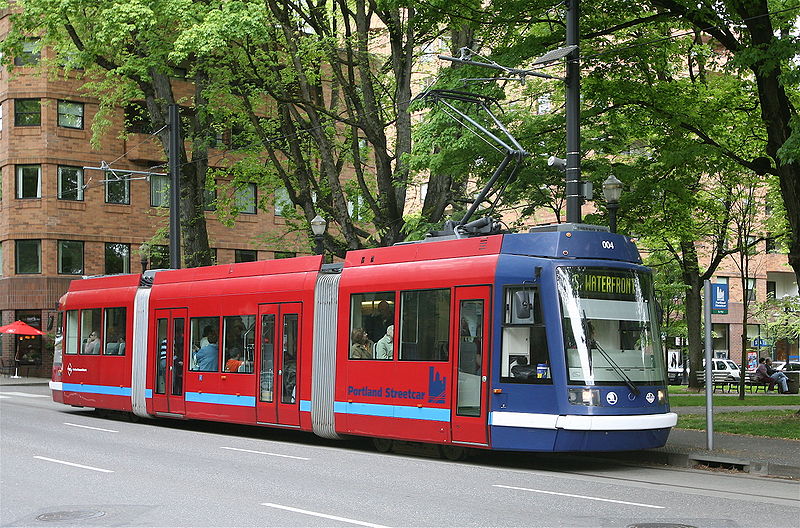
STREETCAR ROUTES
| A | A Loop Streetcar Line | Oregon Museum of Science & Industry (OMSI) – Tilikum Crossing - SW Harrison St. – SW Mill St. - 10th Ave. - Broadway Bridge - NE Weidler St. - NE 7th Ave. - NE Oregon Street - SE Martin Luther King Jr. Blvd. - Oregon Museum of Science & Industry (OMSI) [Loop line, clockwise] |
| B | B Loop Streetcar Line | Oregon Museum of Science & Industry (OMSI) – SE/NE Grand Ave. - NE Broadway - Broadway Bridge - 11th Ave. – SW Market St. [back: SW Mill St.] - SW Harrison St. – Tilikum Crossing - Oregon Museum of Science & Industry (OMSI) [Loop line, counterclockwise] |
| NS | North-South Streetcar Line | Good Samaritan Hospital – Lovejoy St. [back: Northrup St.] – 11th Ave. [back: 10th Ave.] – SW Harrison St. – South Waterfront |
Note: Route designations by letter are not used by the operator.
AERIAL TRAMWAY (CABLE CAR) ROUTE
Operator: Oregon Health & Science University (OHSU)
| South Waterfront - Oregon Health & Science University (OHSU) |
CHARACTERISTICS OF THE SYSTEM
NETWORK LENGTH
- Streetcar line: 13 km.
- Light rail lines: 96 km.
- Aerial tramway: 1 km.
HISTORY
- Horse-trams: 1872 - May 1892
- Cable cars: 1890 - 1904
- Streetcars: (1) 17 Nov. 1889 - 28 Feb. 1950; (2) 20 July 2001 - today
- Interurbans (electric): 1890 - 25 Jan. 1958
- Light rail: 5 Sept. 1986 - today
- Aerial tramway (Cable car): 15 Dec. 2006 - today
GAUGE
- Original streetcars (except for the Sellwood line): 1067 mm.
- Interurbans and the Sellwood streetcar line: 1435 mm.
- Light rail and modern streetcars: 1435 mm.
TRAM PRESERVATION
The Oregon Electric Railway Museum (near Salem, south of Portland) and the Willamette Shore Trolley (between lake Oswego and Portland) run vintage Portland streetcars on museum tracks.
SOURCES
- Fox, G. "LRT v. buses: Why Portland chose light rail", Tramways & Urban Transit, Oct. 2009 (72: 862), p.390-392.
- Labbe, J.T. Fares Please! - Those Portland Trolley Years. Caldwell (ID): Caxton, 1980.
- Lietwiler, C. "Portland: Light rail paves the way to a finer future", Tramways & Urban Transit, Jan. 1998 (61: 721), p.18-20.
- Lietwiler, C. "Portland: Now there are four light rail lines", Tramways & Urban Transit, Aug. 2004 (67: 800), p.298-299.
- Lietwiler, C. "Portland: Planning 50 years ahead", Tramways & Urban Transit, Feb. 1998 (61: 722), p.369-375.
- Richard, T. Portland's streetcars. Charleston, SC: Arcadia Publishing, 2006.
- Simons, V. "Portland: Green meets Orange", Tramways & Urban Transit, Dec. 2015 (78: 936), p.473-478.
- Simons, V. "Portland just gets better and better", Tramways & Urban Transit, Nov. 2009 (72: 863), p.420-423.
- Simons, V. "Portland: LRT pathfinder looks to the future", Tramways & Urban Transit, May 2013 (76: 905), p.170-174.
- "Systems Factfile No.163: Portland, USA", Tramways & Urban Transit, June 2021 (84: 1002), p.240-248.
- Taplin, M.R. "Portland: The streetcar makes a welcome comeback", Tramways & Urban Transit, Oct. 2001 (64: 766), p.369-375.
- Wilson, D., Morgan, S. & Clark B. "MAX takes off in Portland", Modern Tramway & Light Rail Transit, May 1987 (50: 593), p.154-165.
- Thompson, R. Portland's interurban railway. Charleston (NC): Arcadia Publishing, 2012
WIKIS
- MAX Light Rail
- Portland Aerial Tram
- MAX Light Rail
- Portland Streetcar
- Portland Vintage Trolley
- Rose City Transit
- TriMet
- Willamette Shore Trolley
WEB SITES
- New York Subway: Portland Streetcar
- Oregon Pacific Railroad - History of the Portland Traction Co. & Pepco
- Portland Streetcar
- Portland Trolleys & Streetcars
- TriMet
Special thanks to Russell Powers from Denver CO for information on the history of the Portland system.
Copyright Gabor Sandi 1998-2026
Disclaimer: Everything on this site was written and/or prepared at the author's discretion. The author has tried to be accurate where facts are presented, but this does not mean that these facts are necessarily accurate. People needing more reliable information should refer to appropriate sources presented, on the Internet or elsewhere, by authoritative professional or academic bodies.
To get in touch with the webmaster, send an e-mail to g_sandi at hotmail.com.
Flags on this site are from the FOTW Flags Of The World website.